Erie Canal
Also known as: Schoharie Crossing State Historic Site

Why it's listed
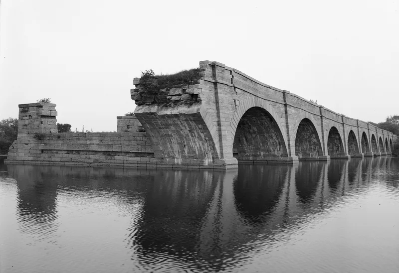
This stretch of the Erie Canal near Fort Hunter, New York, runs just over three and a half miles and crosses Schoharie Creek. It holds the original 1820 canal, which was 40 feet wide and four feet deep, and the 1841 enlarged canal, at 70 by seven feet more than three times its size. The two share one course in the east and diverge to the west. The Schoharie Aqueduct carried the canal over the creek. Six surviving locks, including Yankee Hill Lock and the Empire Lock built by James C. Ott in 1838-41, mark the route, along with arched masonry culverts and an iron culvert. Five of 14 major buildings contribute, among them a Greek Revival grocery, taverns converted for canal traffic and two Dutch barns at Wemp's Basin. Six canal settlements sites probably hold archaeological remains. Much of the land is a state historic site, with farmland, woods and private homes alongside.
Significance in brief: The landmark preserves both the original 1820 Erie Canal and the much larger 1841 enlargement on the same stretch, along with the Schoharie Aqueduct that carried the canal across Schoharie Creek. It also contains locks, culverts and sites of canal-side settlements likely to hold archaeological remains. Together they show how the canal operated and how it was improved over time.
Machine-generated summary. This summary was generated by a language model from the official nomination document and has not been reviewed line by line by an editor. It may contain errors. Check the source document before relying on any detail. Source: nomination document (PDF) · National Archives catalog entry. NRHP reference 66000530, listed October 15, 1966. Summary generated October 2026 (model claude-sonnet-5-5, prompt v1.0-2026-10-29, confidence medium).
Key facts
| Address | 6 mi. W of Amsterdam on NY 5S, Fort Hunter |
|---|---|
| County | Montgomery County |
| Listed | October 15, 1966 |
| Reference number | 66000530 |
| Resource type | District |
| Architect / builder | James C. Ott (built the Empire Lock, 1838-41) |
| Areas of significance | Commerce, Historic - Non-Aboriginal, Engineering, Transportation, Exploration/Settlement |
| Level of significance | National |
| National Historic Landmark | Yes, designated October 9, 1960 |
| Status (as stated in the nomination) | Condition varies: some features are well preserved, others deteriorated, ruined, filled or overgrown. Parts are a state historic site, some buildings are private residences, and some are unused. |
| Acreage | 168 |
| Coordinates | 42.94210, -74.28022 (NPS GIS) |
What listing means for this property
This is a historic district. Buildings within its boundary are either contributing (they add to the district's significance) or non-contributing. Owners of contributing income-producing buildings can claim the 20% federal rehabilitation tax credit; homeowners should look at state credits. National Register districts impose no design review by themselves; a local historic district ordinance, if one exists, does (the difference explained).
General information, not legal or tax advice. Rules change; confirm with your State Historic Preservation Office or a qualified adviser.
Sources and further reading
- National Park Service, National Register of Historic Places database (snapshot May 2026), reference 66000530.
- Nomination form (PDF, National Archives) — catalog entry
- Wikipedia article (used for cross-checking only; text not reproduced here)
- Wikidata Q7432017
- This listing as JSON
Last updated October 2026. Found an error? See the editorial policy for how to report it.