Fort Jay
Also known as: Fort Columbus

Why it's listed
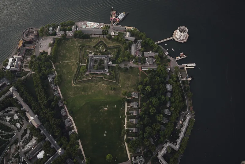
Fort Jay occupies Governors Island in New York Harbor and is a pentagonal fortification with four masonry bastions, a dry moat and a ring of two-story brick officers' quarters around a square courtyard. Work began in 1794 amid fears of war with France, and an earthwork completed in 1798 was named for John Jay. Between 1806 and 1808 the fort was largely rebuilt in stronger materials and renamed Fort Columbus, a name changed back to Fort Jay in 1904. It never fought an enemy, as the British fleet did not attack the city during the War of 1812. Its most striking feature is the Federal-style stone gateway, shaped like an arc de triomphe, with four Doric pilasters, a low-arched opening within a blind arch, and a crowning trophy of flags, cannon, a liberty cap and a spread eagle. The quarters have Tuscan-columned verandas and low-pitched gable roofs.
Significance in brief: The fort is significant as an early federal harbor defense for New York, built under threat of war with France and rebuilt before the War of 1812. It also has notable military architecture, including a Federal-style entrance gate with French influence and a trophee d'armes. It is a well-preserved example of its type.
Machine-generated summary. This summary was generated by a language model from the official nomination document and has not been reviewed line by line by an editor. It may contain errors. Check the source document before relying on any detail. Source: nomination document (PDF) · National Archives catalog entry. NRHP reference 74001268, listed March 27, 1974. Summary generated October 2026 (model claude-sonnet-5-5, prompt v1.0-2026-10-29, confidence medium).
Key facts
| Address | Governor's Island, New York |
|---|---|
| County | Manhattan |
| Listed | March 27, 1974 |
| Reference number | 74001268 |
| Resource type | Structure |
| Architectural style | Federal |
| Areas of significance | Military |
| Level of significance | National |
| Status (as stated in the nomination) | Described as having a well-preserved dry moat; the form marks the property as occupied, in military use, and altered. Owned by the U.S. Coast Guard. |
| Acreage | 0.9 |
| Within district | Governors Island |
| Coordinates | 40.69137, -74.01586 (NPS GIS) |
What listing means for this property
National Register listing is honorary: it recognises significance and does not restrict what a private owner may do without federal money or permits. It unlocks the 20% federal rehabilitation tax credit for income-producing buildings, state credits in many states, and Section 106 review when federal agencies are involved. See what listing means in practice.
General information, not legal or tax advice. Rules change; confirm with your State Historic Preservation Office or a qualified adviser.
Sources and further reading
- National Park Service, National Register of Historic Places database (snapshot May 2026), reference 74001268.
- Nomination form (PDF, National Archives) — catalog entry
- Wikipedia article (used for cross-checking only; text not reproduced here)
- Wikidata Q5470967
- This listing as JSON
Last updated October 2026. Found an error? See the editorial policy for how to report it.