Concordia Cemetery

Why it's listed
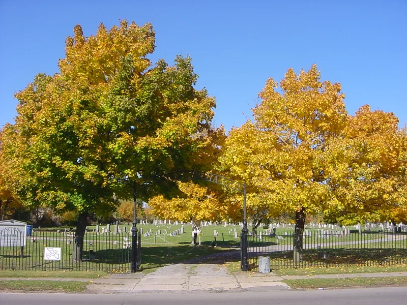
Concordia Cemetery occupies about 15 acres on Buffalo's east side, roughly three miles from downtown. Three German churches, Holy Trinity, St. Peter's and St. Stephen's, founded it in 1859 on land that already held a farmhouse and barn, which became the cemetery office and maintenance building. The grounds follow a simple grid along a central drive, with one section reserved for each congregation. About 16,800 burials are recorded, marked by marble, Medina sandstone and later granite monuments. Many inscriptions are in German and name the towns where immigrants were born. A nineteenth-century cast and wrought iron fence runs along Walden Avenue, and a replica entrance arch was installed in 2006. The cemetery is valued for its connection to Buffalo's German community, which by 1900 made up about 40 percent of the city's population. Its monuments and setting preserve evidence of a tightly knit ethnic neighborhood that has largely dispersed.
Significance in brief: The nomination argues significance under Criterion A for the cemetery's link to Buffalo's German immigrant and German American community between 1859 and 1957. Its German-language inscriptions record family origins and cultural identity. Its location in the historic German neighborhood is a rare physical reminder of a once large community that is now largely dispersed.
Machine-generated summary. This summary was generated by a language model from the official nomination document and has not been reviewed line by line by an editor. It may contain errors. Check the source document before relying on any detail. Source: nomination document (PDF) · National Archives catalog entry. NRHP reference 08000106, listed February 28, 2008. Summary generated October 2026 (model claude-sonnet-5-5, prompt v1.0-2026-10-29, confidence high).
Key facts
| Address | 438 Walden Ave., Buffalo |
|---|---|
| County | Erie County |
| Listed | February 28, 2008 |
| Reference number | 08000106 |
| Resource type | Site |
| Period of significance | 1859-1957 |
| Criteria |
|
| Areas of significance | Social History, European |
| Level of significance | Local |
| Status (as stated in the nomination) | Still in use as a cemetery. The gateway arch was replaced in 2006, and the property is described as substantially unaltered with a high degree of integrity. |
| Acreage | 15 |
| Coordinates | 42.90822, -78.81949 (NPS GIS) |
What listing means for this property
Sites (archaeological sites, battlefields, landscapes) are often listed with a restricted address to protect them from looting or disturbance. Listing is honorary for private owners; federal undertakings on or near the site go through Section 106 review, and state laws may protect burials and artefacts regardless of listing.
General information, not legal or tax advice. Rules change; confirm with your State Historic Preservation Office or a qualified adviser.
Sources and further reading
- National Park Service, National Register of Historic Places database (snapshot May 2026), reference 08000106.
- Nomination form (PDF, National Archives) — catalog entry
- Wikipedia article (used for cross-checking only; text not reproduced here)
- Wikidata Q5158953
- This listing as JSON
Last updated October 2026. Found an error? See the editorial policy for how to report it.