Garfield Place Historic District

Why it's listed
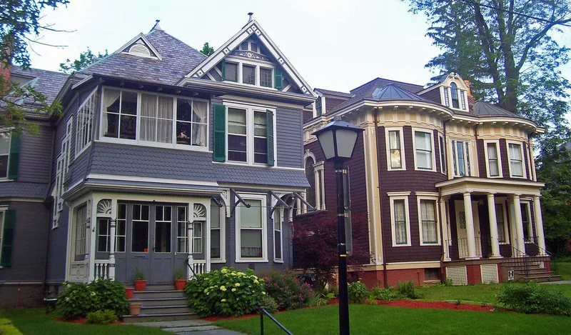
Garfield Place is a tree-lined residential street on a hill above the Hudson Valley in Poughkeepsie. The historic district runs from Montgomery Street to Franklin Street and includes about twenty-five dwellings and several outbuildings. Most houses date from the mid-nineteenth century, with a few from the early twentieth. They range from simple gabled structures to elaborate buildings with towers, brackets, cupolas, porches and mansard roofs. The land was part of the Little Commons and was laid out as building lots after 1836 by a group of partners. Building began in 1852, when partner George Corlies built a home to show the lifestyle the neighborhood offered. The street, once South Liberty Street, was renamed Garfield Place in 1881. Its residents included merchants, physicians, lawyers, bankers and manufacturers, and the district shows the social and economic life of Poughkeepsie in that period. Surviving features include a wooden kiosk from about 1861 and a carriage house.
Significance in brief: The district is described as having significant architectural quality and as a tangible illustration of part of Poughkeepsie's social history. Its houses reflect the prosperity of a small industrial city and keep a largely original character and integrity. The street attracted merchants, professionals, bankers and especially manufacturers.
Machine-generated summary. This summary was generated by a language model from the official nomination document and has not been reviewed line by line by an editor. It may contain errors. Check the source document before relying on any detail. Source: nomination document (PDF) · National Archives catalog entry. NRHP reference 72000832, listed November 29, 1972. Summary generated October 2026 (model claude-sonnet-5-5, prompt v1.0-2026-10-29, confidence medium).
Key facts
| Address | Both sides of Garfield Pl., Poughkeepsie |
|---|---|
| County | Dutchess County |
| Listed | November 29, 1972 |
| Reference number | 72000832 |
| Resource type | District |
| Period of significance | 19th Century (specific date 1873) |
| Areas of significance | Architecture |
| Level of significance | Local |
| Status (as stated in the nomination) | Listed as in excellent condition, unaltered and original, occupied, and used mainly as private residences. |
| Acreage | 20 |
| Coordinates | 41.69772, -73.92989 (NPS GIS) |
What listing means for this property
This is a historic district. Buildings within its boundary are either contributing (they add to the district's significance) or non-contributing. Owners of contributing income-producing buildings can claim the 20% federal rehabilitation tax credit; homeowners should look at state credits. National Register districts impose no design review by themselves; a local historic district ordinance, if one exists, does (the difference explained).
General information, not legal or tax advice. Rules change; confirm with your State Historic Preservation Office or a qualified adviser.
Sources and further reading
- National Park Service, National Register of Historic Places database (snapshot May 2026), reference 72000832.
- Nomination form (PDF, National Archives) — catalog entry
- Wikipedia article (used for cross-checking only; text not reproduced here)
- Wikidata Q5523095
- This listing as JSON
Last updated October 2026. Found an error? See the editorial policy for how to report it.