Chenango Canal Prism and Lock 107

Why it's listed
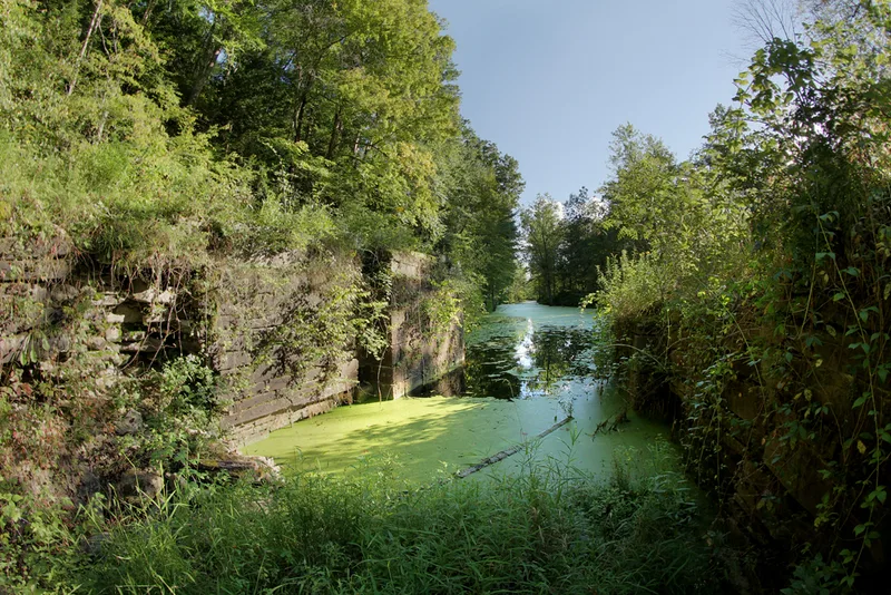
A quarter-mile stretch of the Chenango Canal near Chenango Forks preserves the water-filled canal channel, its towpath, the remains of Lock 107, and a guard lock and dam on the Chenango River that diverted river water into the canal. Built between 1834 and 1836 by the State of New York, the canal ran 97 miles between Utica and Binghamton and used 114 locks. It struggled commercially because of difficult terrain, and the railroad of the 1860s cut the trip from four days to half a day. The state abandoned it in 1878. Since the canal was never enlarged like the Erie, this section keeps the dimensions and single-chamber lock design of the first generation of New York canals: a prism 42 feet wide at the top, 26 feet at the bottom, and four feet deep. The east lock wall is well preserved, and the towpath now serves as a hiking trail. It was recognized for its role in state transportation and early canal engineering.
Significance in brief: The nomination argues the section is significant under Criterion A as part of the New York State canal system of the early nineteenth century, and under Criterion C as an example of early canal engineering and construction. Because the Chenango Canal was never enlarged, it preserves the scale and specifications of the first generation of state canals, similar to the original Erie Canal, very little of which survives.
Machine-generated summary. This summary was generated by a language model from the official nomination document and has not been reviewed line by line by an editor. It may contain errors. Check the source document before relying on any detail. Source: nomination document (PDF) · National Archives catalog entry. NRHP reference 10000359, listed June 18, 2010. Summary generated October 2026 (model claude-sonnet-5-5, prompt v1.0-2026-10-29, confidence medium).
Key facts
| Address | River Rd, Chenango Forks |
|---|---|
| County | Broome County |
| Listed | June 18, 2010 |
| Reference number | 10000359 |
| Resource type | Structure |
| Period of significance | 1833-1878 |
| Criteria |
|
| Areas of significance | Transportation, Maritime History, Commerce |
| Level of significance | State |
| Status (as stated in the nomination) | Roughly a quarter mile of the canal is watered and state-owned within and beside Chenango Valley State Park; the north end of the lock is filled, some west wall stone is missing, and the towpath is maintained as a hiking trail. |
| Acreage | 2.4 |
| Coordinates | 42.24228, -75.83954 (NPS GIS) |
What listing means for this property
National Register listing is honorary: it recognises significance and does not restrict what a private owner may do without federal money or permits. It unlocks the 20% federal rehabilitation tax credit for income-producing buildings, state credits in many states, and Section 106 review when federal agencies are involved. See what listing means in practice.
General information, not legal or tax advice. Rules change; confirm with your State Historic Preservation Office or a qualified adviser.
Sources and further reading
- National Park Service, National Register of Historic Places database (snapshot May 2026), reference 10000359.
- Nomination form (PDF, National Archives) — catalog entry
- Wikipedia article (used for cross-checking only; text not reproduced here)
- Wikidata Q14706224
- This listing as JSON
Last updated October 2026. Found an error? See the editorial policy for how to report it.