Pan Burying Ground
Also known as: Pan Cemetery; East Burying Ground; East Cemetery

Why it's listed
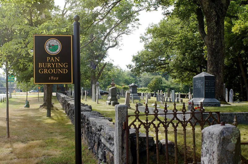
Pan Burying Ground is a long, narrow town cemetery on the north side of Main Street (Route 117) in Bolton, Massachusetts. Bolton bought the land in 1822 from farmer Oliver Barrett, when the Old South Burying Ground was nearing capacity. Surveyor Silas Holman laid out forty family plots in five blocks beside a central cart path, and that grid is still visible. The grounds were enlarged in 1860 and 1963 and now cover 3.3 acres. About 400 markers show the usual shift from slate to marble to granite, with urn-and-willow carvings, signed work by regional carvers, obelisks and pillar monuments. A seven-chamber granite-fronted tomb of 1839 holds the names of leading townspeople, and it is the only group vault in a Bolton cemetery. Two cast-iron gates and a fieldstone and granite wall line the street. Prominent families from the town center bought plots here, making it the town's most fashionable burying ground. Burials continue today.
Significance in brief: The nomination presents it as a well-preserved roadside New England graveyard of the 1820s that keeps its original rectilinear layout. It holds a range of slate, marble and granite markers, including some of the town's best-preserved slates and most ornate obelisks and pillar monuments. It is the only Bolton cemetery with a group burial vault, and it became the most fashionable burying ground, with plots of prominent town-center families.
Machine-generated summary. This summary was generated by a language model from the official nomination document and has not been reviewed line by line by an editor. It may contain errors. Check the source document before relying on any detail. Source: nomination document (PDF) · National Archives catalog entry. NRHP reference 07000682, listed July 11, 2007. Summary generated October 2026 (model claude-sonnet-5-5, prompt v1.0-2026-10-29, confidence medium).
Key facts
| Address | 477 Main St., Bolton |
|---|---|
| County | Worcester County |
| Listed | July 11, 2007 |
| Reference number | 07000682 |
| Resource type | Site |
| Architect / builder | Silas Holman (surveyor who laid out the cemetery) |
| Architectural style | N/A (Greek Revival and Victorian Gothic markers and gates noted) |
| Areas of significance | Art, Landscape Architecture, Community Planning and Development, Social History |
| Level of significance | Local |
| Status (as stated in the nomination) | Still open to burials; described as generally well maintained, with some wall bowing and loosening stones and some missing or damaged markers. |
| Acreage | 3.3 |
| Within district | Pan Historic District |
| Coordinates | 42.43066, -71.58953 (NPS GIS) |
What listing means for this property
Sites (archaeological sites, battlefields, landscapes) are often listed with a restricted address to protect them from looting or disturbance. Listing is honorary for private owners; federal undertakings on or near the site go through Section 106 review, and state laws may protect burials and artefacts regardless of listing.
General information, not legal or tax advice. Rules change; confirm with your State Historic Preservation Office or a qualified adviser.
Sources and further reading
- National Park Service, National Register of Historic Places database (snapshot May 2026), reference 07000682.
- Nomination form (PDF, National Archives) — catalog entry
- Wikipedia article (used for cross-checking only; text not reproduced here)
- Wikidata Q7129628
- This listing as JSON
Last updated October 2026. Found an error? See the editorial policy for how to report it.