Christ Church Burial Ground

Why it's listed
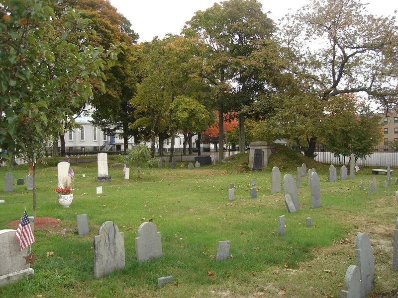
Christ Church Burial Ground occupies a square, flat lot at 54-60 School Street in Quincy, enclosed by a wrought iron fence with a gate between two granite posts. It marks the site of the first Anglican church in what was then Braintree, built in 1727 on land deeded in 1725 by William and Benjamin Veazie. The wooden church was dismantled in 1832, but its low building site and two family vaults remain, and granite foundation stones now sit beneath the fence. About seventy-five marked graves survive, with slate and marble stones dating from 1737 into the post-Civil War era. Carvings include death's-heads, cherubs, portrait effigies, urns and willows. A finely carved slate marker for Ralph Shirley, son of Royal Governor William Shirley, carries Latin and English inscriptions. Burials here include the Reverend Ebenezer Miller, the first rector, and Joseph Cleverly, a churchman and teacher of John Adams. The ground is valued for its link to the parish founded in 1689 and its record of local burial practice.
Significance in brief: The site is significant as the location of the original building and cemetery of the First Church of England in Braintree, the oldest Episcopal parish in Quincy and the second formed in Massachusetts. Parishioners were buried here from 1727 through the post-Civil War era. The ground also holds gravestones showing a range of mortuary art and the graves of figures such as the first rector and a schoolmaster of John Adams.
Machine-generated summary. This summary was generated by a language model from the official nomination document and has not been reviewed line by line by an editor. It may contain errors. Check the source document before relying on any detail. Source: nomination document (PDF) · National Archives catalog entry. NRHP reference 89001372, listed September 20, 1989. Summary generated October 2026 (model claude-sonnet-5-5, prompt v1.0-2026-10-29, confidence medium).
Key facts
| Address | 54--60 School St., Quincy |
|---|---|
| County | Norfolk County |
| Listed | September 20, 1989 |
| Reference number | 89001372 |
| Resource type | Site |
| Criteria |
|
| Areas of significance | Community Planning and Development, Architecture |
| Level of significance | Local |
| Status (as stated in the nomination) | Condition is described as good; the site is enclosed by a wrought iron fence and sits next to a Catholic church on a busy street. |
| Acreage | 0.3 |
| Coordinates | 42.24423, -71.00206 (NPS GIS) |
What listing means for this property
Sites (archaeological sites, battlefields, landscapes) are often listed with a restricted address to protect them from looting or disturbance. Listing is honorary for private owners; federal undertakings on or near the site go through Section 106 review, and state laws may protect burials and artefacts regardless of listing.
General information, not legal or tax advice. Rules change; confirm with your State Historic Preservation Office or a qualified adviser.
Sources and further reading
- National Park Service, National Register of Historic Places database (snapshot May 2026), reference 89001372.
- Nomination form (PDF, National Archives) — catalog entry
- Wikipedia article (used for cross-checking only; text not reproduced here)
- Wikidata Q5108767
- This listing as JSON
Last updated October 2026. Found an error? See the editorial policy for how to report it.