Lynnwood

Why it's listed
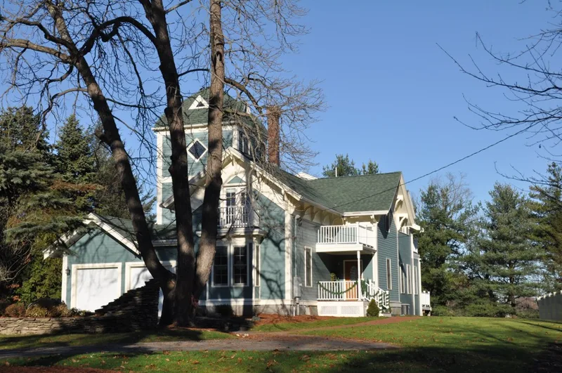
Lynnwood is a house at 5 Linden Avenue in Wakefield, Massachusetts, built about 1858 on the south shore of Crystal Lake, then known as Smith's Pond. It is an idiosyncratic Stick Style design with a gabled main block, a projecting transverse gable, a tower on the southwest, arched braces with pendants under the eaves, and drip molds over paired windows. Later changes include the top of the tower and an east tower around 1900, an enclosed porch in 1970 and a new entry in 1982. The house was built for the daughter of the Lord family, who were involved in a Lynn newspaper. It was the last of three houses on the lake's south shore built before 1874. Their construction reflects the commuting convenience created by the railroad, which arrived in 1845 on farmland laid out for development by James Sullivan in 1844. The house is considered one of the town's best Stick Style examples.
Significance in brief: The nomination calls it one of Wakefield's best examples of Stick Style residential architecture. It also reflects the suburban development of the town after the railroad arrived in the mid-19th century. It is described as meeting Criteria A and C at the local level, with good integrity.
Machine-generated summary. This summary was generated by a language model from the official nomination document and has not been reviewed line by line by an editor. It may contain errors. Check the source document before relying on any detail. Source: nomination document (PDF) · National Archives catalog entry. NRHP reference 89000705, listed July 6, 1989. Summary generated October 2026 (model claude-sonnet-5-5, prompt v1.0-2026-10-29, confidence medium).
Key facts
| Address | 5 Linden Ave., Wakefield |
|---|---|
| County | Middlesex County |
| Listed | July 6, 1989 |
| Reference number | 89000705 |
| Resource type | Building |
| Architectural style | Stick Style |
| Criteria |
|
| Areas of significance | Community Planning and Development, Architecture |
| Level of significance | Local |
| Status (as stated in the nomination) | Present use is a dwelling; condition is listed as fair. |
| Acreage | 1.3 |
| Coordinates | 42.49046, -71.07183 (NPS GIS) |
What listing means for this property
National Register listing is honorary: it recognises significance and does not restrict what a private owner may do without federal money or permits. It unlocks the 20% federal rehabilitation tax credit for income-producing buildings, state credits in many states, and Section 106 review when federal agencies are involved. See what listing means in practice.
General information, not legal or tax advice. Rules change; confirm with your State Historic Preservation Office or a qualified adviser.
Sources and further reading
- National Park Service, National Register of Historic Places database (snapshot May 2026), reference 89000705.
- Nomination form (PDF, National Archives) — catalog entry
- Wikipedia article (used for cross-checking only; text not reproduced here)
- Wikidata Q6709487
- This listing as JSON
Last updated October 2026. Found an error? See the editorial policy for how to report it.