Double-arch Sandstone Bridge

Why it's listed
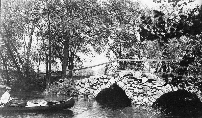
Built in 1835 on Hampshire Road in Methuen, this twin-arch sandstone bridge was laid without mortar and replaced an earlier wooden bridge. It measures roughly 40 by 15 feet and was built for the Town of Methuen, according to town meeting records of March 1835. The bridge carried traffic until 1963, when construction of Interstate 93 required the Spicket River to be rechanneled and Hampshire Road to be realigned. It now sits beside an abandoned river channel, near a suburban mall and west of the Route 93 overpass. Its listing rests on its status as the only local example of dry-laid stone arch bridge construction and on its value as a reminder of where the river and road ran before the interstate. The bridge retains its original location, design, setting, materials and workmanship. The boundary covers the bridge, its footings and five feet of roadway on either side.
Significance in brief: The nomination argues the bridge is the only local example of dry-laid stone arch bridge construction. It also recalls the pre-Route 93 locations of the Spicket River and Hampshire Road. It retains integrity of location, design, setting, materials, workmanship and association.
Machine-generated summary. This summary was generated by a language model from the official nomination document and has not been reviewed line by line by an editor. It may contain errors. Check the source document before relying on any detail. Source: nomination document (PDF) · National Archives catalog entry. NRHP reference 84002326, listed June 20, 1984. Summary generated October 2026 (model claude-sonnet-5-5, prompt v1.0-2026-10-29, confidence medium).
Key facts
| Address | Hampshire Rd., Methuen |
|---|---|
| County | Essex County |
| Listed | June 20, 1984 |
| Reference number | 84002326 |
| Resource type | Structure |
| Criteria |
|
| Areas of significance | Architecture |
| Level of significance | Local |
| Status (as stated in the nomination) | Present use is listed as none; the form describes the condition as fair and the setting as rural, adjacent to a suburban mall. The bridge went out of use in 1963. |
| Acreage | 0.9 |
| Coordinates | 42.74250, -71.20764 (NPS GIS) |
What listing means for this property
For a publicly owned building or structure, listing mainly matters when federal funds, permits or licences are involved: projects then go through Section 106 review so effects on the property are considered. Listing also strengthens applications for preservation grants and, for leased income-producing uses, can enable the federal rehabilitation tax credit.
General information, not legal or tax advice. Rules change; confirm with your State Historic Preservation Office or a qualified adviser.
Sources and further reading
- National Park Service, National Register of Historic Places database (snapshot May 2026), reference 84002326.
- Nomination form (PDF, National Archives) — catalog entry
- Wikipedia article (used for cross-checking only; text not reproduced here)
- Wikidata Q5299582
- This listing as JSON
Last updated October 2026. Found an error? See the editorial policy for how to report it.