Baker's Island Light Station

Why it's listed
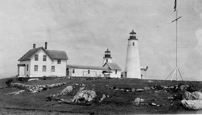
Bakers Island Light Station sits on an island in outer Salem Harbor, Massachusetts, and has guided vessels since 1798. A group of Salem men erected a daytime marker there in 1791, Congress authorized a light in 1796, and the first keeper lit it on January 3, 1798. The present white conical tower of stone and concrete, 59 feet high, dates from 1821. Two wood-frame keepers' dwellings were built in 1878 and improved in 1958, and a brick fog signal building followed in 1907. The station figures in several episodes recorded in its history. During the War of 1812, Keeper Joseph Perkins is said to have rowed out and piloted the frigate Constitution into Salem Harbor while two British warships chased it. In 1817 one of the two original lights was ordered extinguished, and ships were wrecked on the rocks before it was restored in 1820. The light is now automated and unattended, and it is regarded as a scenic view in the harbor.
Significance in brief: The station dates to a light first illuminated in 1798 after Congress authorized it in 1796, and it served commerce and navigation at the entrance to Salem Harbor. The form also recounts that a keeper piloted the frigate Constitution to safety during the War of 1812. The light is described as a scenic view in outer Salem Harbor.
Machine-generated summary. This summary was generated by a language model from the official nomination document and has not been reviewed line by line by an editor. It may contain errors. Check the source document before relying on any detail. Source: nomination document (PDF) · National Archives catalog entry. NRHP reference 76000289, listed November 21, 1976. Summary generated October 2026 (model claude-sonnet-5-5, prompt v1.0-2026-10-29, confidence medium).
Key facts
| Address | E of Salem on Baker's Island, Salem |
|---|---|
| County | Essex County |
| Listed | November 21, 1976 |
| Reference number | 76000289 |
| Resource type | Building |
| Areas of significance | Commerce, Military, Transportation |
| Level of significance | National |
| Status (as stated in the nomination) | Automated and unattended light; the form marks the status as unoccupied, with condition fair and the property altered but on its original site. |
| Acreage | 11.5 |
| Coordinates | 42.53727, -70.78679 (NPS GIS) |
What listing means for this property
For a publicly owned building or structure, listing mainly matters when federal funds, permits or licences are involved: projects then go through Section 106 review so effects on the property are considered. Listing also strengthens applications for preservation grants and, for leased income-producing uses, can enable the federal rehabilitation tax credit.
General information, not legal or tax advice. Rules change; confirm with your State Historic Preservation Office or a qualified adviser.
Sources and further reading
- National Park Service, National Register of Historic Places database (snapshot May 2026), reference 76000289.
- Nomination form (PDF, National Archives) — catalog entry
- Wikipedia article (used for cross-checking only; text not reproduced here)
- Wikidata Q4849264
- This listing as JSON
Last updated October 2026. Found an error? See the editorial policy for how to report it.