Santuit Historic District

Why it's listed
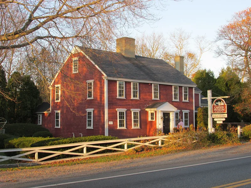
Santuit is a small group of houses and outbuildings along Falmouth Road (Route 28) in Cotuit, Barnstable, set at a crossroads leading toward Sandwich and Mashpee/Falmouth. Most of the buildings belonged to the Crocker family. The oldest, the Ebenezer Crocker Homestead, is said to have been moved here by oxen around 1739. The district also includes Georgian houses from about 1769 and 1782, Federal houses from about 1796, and an Italianate house from about 1860. Santuit was the inland center of a mainly agricultural community and held a community focus while land travel and land-based resources were at their height. Over time maritime activity shifted the village's attention to the coast at Cotuit Port and Cotuit Highland. Some of the houses served as a tavern, Cotuit's first library and a post office. Six buildings contribute to the district and three newer ones do not. Its well preserved houses reflect the area's early prosperity.
Significance in brief: The district represents the core of the first settlement of Cotuit village and its early role as the economic center of one of Barnstable's southern villages. It keeps a well preserved group of Georgian, Federal and Italianate houses. It is also closely tied to settlement patterns, commerce and the Crocker family.
Machine-generated summary. This summary was generated by a language model from the official nomination document and has not been reviewed line by line by an editor. It may contain errors. Check the source document before relying on any detail. Source: nomination document (PDF) · National Archives catalog entry. NRHP reference 87000319, listed November 10, 1987. Summary generated October 2026 (model claude-sonnet-5-5, prompt v1.0-2026-10-29, confidence high).
Key facts
| Address | MA 28, Barnstable |
|---|---|
| County | Barnstable County |
| Listed | November 10, 1987 |
| Reference number | 87000319 |
| Resource type | District |
| Period of significance | 1739-1860 |
| Architectural style | Georgian, Federal, Italianate |
| Criteria |
|
| Areas of significance | Commerce, Exploration/Settlement, Architecture |
| Level of significance | National, State, Local |
| Status (as stated in the nomination) | General condition is given as fair to excellent; present use is commercial and residential. Of the buildings, six contribute and three do not, including newer construction. |
| Acreage | 10.5 |
| Coordinates | 41.63803, -70.45065 (NPS GIS) |
What listing means for this property
This is a historic district. Buildings within its boundary are either contributing (they add to the district's significance) or non-contributing. Owners of contributing income-producing buildings can claim the 20% federal rehabilitation tax credit; homeowners should look at state credits. National Register districts impose no design review by themselves; a local historic district ordinance, if one exists, does (the difference explained).
General information, not legal or tax advice. Rules change; confirm with your State Historic Preservation Office or a qualified adviser.
Sources and further reading
- National Park Service, National Register of Historic Places database (snapshot May 2026), reference 87000319.
- Nomination form (PDF, National Archives) — catalog entry
- Wikipedia article (used for cross-checking only; text not reproduced here)
- Wikidata Q7420719
- This listing as JSON
Last updated October 2026. Found an error? See the editorial policy for how to report it.