Thornton Avenue-Murray Hill Historic District
Also known as: See Also:Blunt, Ainsworth E., House

Why it's listed
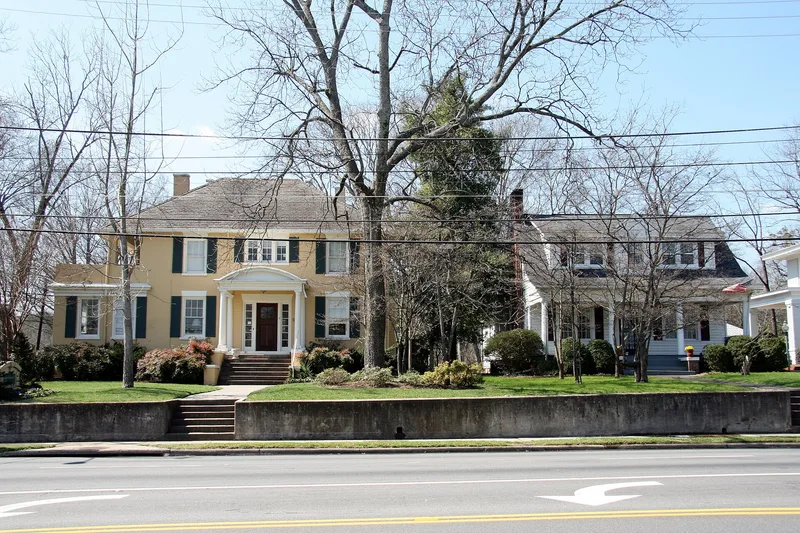
This Dalton, Georgia neighborhood grew along Thornton Avenue, a former wagon path that became U.S. Highway 41, and extends west through the Murray Hill subdivisions to West Hill Cemetery. The oldest surviving house, built in 1848 for Dalton's first mayor and postmaster Ainsworth E. Blunt, is now a house museum. After Civil War damage to downtown, wealthy bankers, mill owners and physicians built Queen Anne, Italianate, Greek Revival and Neo-classical homes along the avenue. In 1937 the Acme Lumber and Supply Company developed Murray Hill, adding Colonial, English Vernacular Revival and Craftsman houses for middle-class families. Gabled-ell Folk Victorian houses and bungalows show common Georgia housing types. The cemetery holds a Confederate burying ground and a rare stone chapel. The district is recognized for its architecture, its community planning, and its main streets laid out in Captain Edward White's 1846-1847 city plan.
Significance in brief: It is described as Dalton's oldest and largest documented residential neighborhood, showing more than 100 years of development. It includes leading architectural styles from Greek Revival to Craftsman and vernacular house types. It is also significant for community planning, through the 1930s subdivisions and the 1846-1847 street plan.
Machine-generated summary. This summary was generated by a language model from the official nomination document and has not been reviewed line by line by an editor. It may contain errors. Check the source document before relying on any detail. Source: nomination document (PDF) · National Archives catalog entry. NRHP reference 92000669, listed June 4, 1992. Summary generated October 2026 (model claude-sonnet-5-5, prompt v1.0-2026-10-29, confidence high).
Key facts
| Address | Roughly bounded by Crawford St., Thornton Ave., W. Franklin St., Valley Dr., Emory St. and West Hill Cemetery, Dalton |
|---|---|
| County | Whitfield County |
| Listed | June 4, 1992 |
| Reference number | 92000669 |
| Resource type | District |
| Period of significance | 1846-1941 |
| Architect / builder | Lipham, Rev. Charles M. (1880-1964) |
| Architectural style | No style; Greek Revival; Queen Anne; Georgian Revival; Bungalow/Craftsman |
| Criteria |
|
| Areas of significance | Community Planning and Development, Architecture |
| Level of significance | Local |
| Status (as stated in the nomination) | Largely intact residential neighborhood; some historic houses are adaptively used as a gift shop, a jewelry store and a house museum. The eastern side of Thornton Avenue has been altered by commercial development. |
| Acreage | 110 |
| Coordinates | 34.76701, -84.97495 (NPS GIS) |
What listing means for this property
This is a historic district. Buildings within its boundary are either contributing (they add to the district's significance) or non-contributing. Owners of contributing income-producing buildings can claim the 20% federal rehabilitation tax credit; homeowners should look at state credits. National Register districts impose no design review by themselves; a local historic district ordinance, if one exists, does (the difference explained).
General information, not legal or tax advice. Rules change; confirm with your State Historic Preservation Office or a qualified adviser.
Sources and further reading
- National Park Service, National Register of Historic Places database (snapshot May 2026), reference 92000669.
- Nomination form (PDF, National Archives) — catalog entry
- Wikidata Q141819467
- This listing as JSON
Last updated October 2026. Found an error? See the editorial policy for how to report it.