Hofwyl-Broadfield Plantation
Also known as: Hofwyl Plantation

Why it's listed
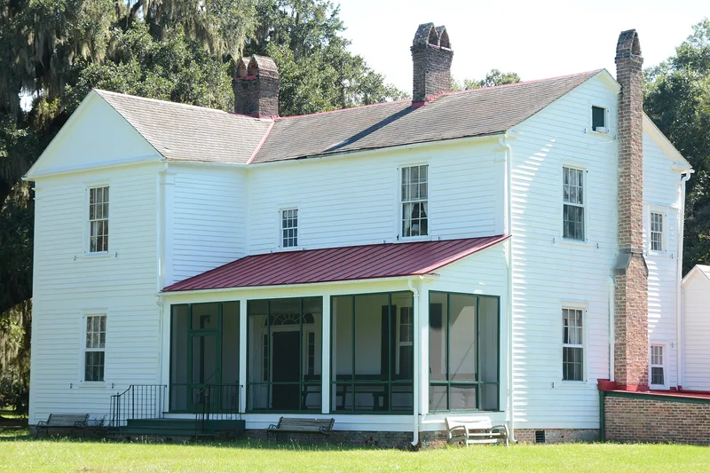
Hofwyl-Broadfield Plantation occupies about 1,268 acres of marsh and pine upland along the Altamaha River in Glynn County, Georgia. Much of it was once rice fields, now visible only as faint outlines, embankments and traces of water ducts. The main house, built low to the ground and probably in the 1850s, has a central hall, a four-room ground-floor plan, federal-style details such as a fanlight, and a marble mantelpiece said to come from a family home in Darien. Outbuildings behind it, mostly early twentieth century, include dairy barns and an ice house. The land passed from Henry Laurens and Lachlan McIntosh to William Brailsford, then to the Troup and Dent families, who named the central portion Hofwyl. Rice was grown there as late as 1917, though it never regained its prewar profitability, and a dairy later sustained the family. The estate was given to the state in 1973, and it illustrates the rise and decline of coastal Georgia's rice industry.
Significance in brief: The nomination argues the property was a center of rice cultivation in coastal Georgia's rice society of the late eighteenth and nineteenth centuries. Its history shows the development and decline of the rice industry over more than a century. It can also help illustrate the way of life on rice plantations.
Machine-generated summary. This summary was generated by a language model from the official nomination document and has not been reviewed line by line by an editor. It may contain errors. Check the source document before relying on any detail. Source: nomination document (PDF) · National Archives catalog entry. NRHP reference 76000635, listed July 12, 1976. Summary generated October 2026 (model claude-sonnet-5-5, prompt v1.0-2026-10-29, confidence medium).
Key facts
| Address | N of Brunswick on U.S. 17, Brunswick |
|---|---|
| County | Glynn County |
| Listed | July 12, 1976 |
| Reference number | 76000635 |
| Resource type | Building |
| Period of significance | 1800-1899 |
| Areas of significance | Architecture, Social History, Agriculture |
| Level of significance | Local |
| Status (as stated in the nomination) | Owned by the state Department of Natural Resources, which received it from the last family owner; the form lists condition as good, with the property marked unoccupied and a museum in process. |
| Acreage | 1268 |
| Coordinates | 31.31026, -81.45136 (NPS GIS) |
What listing means for this property
National Register listing is honorary for a privately owned home: it does not by itself restrict what an owner may do with their own money, and it does not require public access. Restrictions come from local landmark or historic-district ordinances, which are separate (how they differ).
Owner-occupied houses are not eligible for the 20% federal rehabilitation tax credit, which applies to income-producing buildings, but many states offer credits for homeowners. Listing also opens the door to preservation easements and to buying a plaque. Start with what listing means for homeowners, renovating a listed house and selling one.
General information, not legal or tax advice. Rules change; confirm with your State Historic Preservation Office or a qualified adviser.
Sources and further reading
- National Park Service, National Register of Historic Places database (snapshot May 2026), reference 76000635.
- Nomination form (PDF, National Archives) — catalog entry
- Wikipedia article (used for cross-checking only; text not reproduced here)
- Wikidata Q22058900
- This listing as JSON
Last updated October 2026. Found an error? See the editorial policy for how to report it.