Main Road
Also known as: Grand Avenue; Stafford Road

Why it's listed
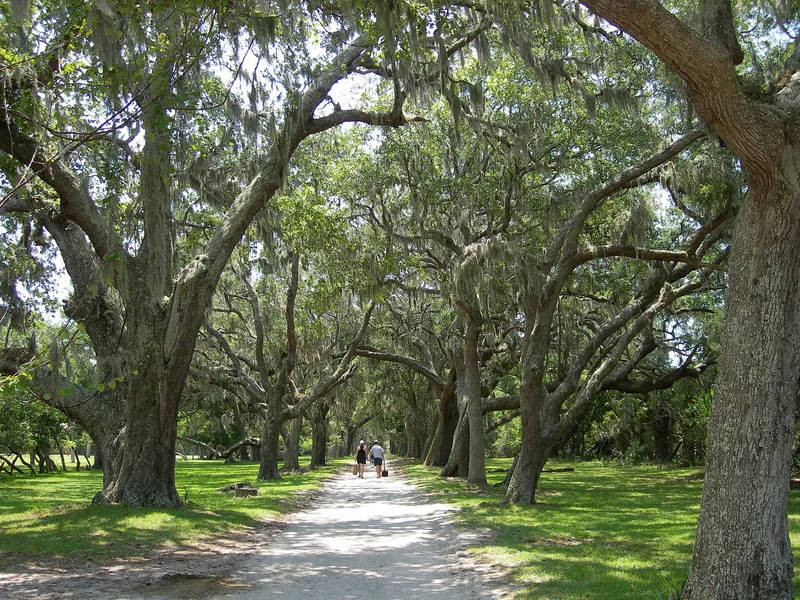
Running about 13 miles down the length of Cumberland Island, this 8-to-10-foot-wide shell-surfaced road connects Dungeness in the south with the High Point and Half Moon Bluff area in the north. It passes through live oak, pine and palmetto woods as well as open ground. An 1802 map shows a road that only linked plantation homes and fields, and parts of today's route follow that line. A continuous north-south road appears on maps from around 1870. Plantation owners such as the Millers and Robert Stafford needed roads wide enough for carriages and for hauling timber and cotton. Later the Carnegie family, with electric cars and automobiles, had the road improved and brought it into its present alignment, adding riding and hunting trails. It links Greyfield, Stafford, Plum Orchard and Rayfield along the way. Listed for its role in transportation, it remains the island's primary route. North of Brickhill Bluff the current road lies west of the 1870 alignment.
Significance in brief: The road is significant in the area of transportation. It has linked the island's antebellum plantations, and later the whole island, for about 150 years as the main north-south route. The Carnegie family brought it into its present alignment and added riding and hunting trails branching from it.
Machine-generated summary. This summary was generated by a language model from the official nomination document and has not been reviewed line by line by an editor. It may contain errors. Check the source document before relying on any detail. Source: nomination document (PDF) · National Archives catalog entry. NRHP reference 84000941, listed February 13, 1984. Summary generated October 2026 (model claude-sonnet-5-5, prompt v1.0-2026-10-29, confidence medium).
Key facts
| Address | Cumberland Island, St. Marys |
|---|---|
| County | Camden County |
| Listed | February 13, 1984 |
| Reference number | 84000941 |
| Resource type | Structure |
| Criteria |
|
| Areas of significance | Transportation |
| Level of significance | State |
| Status (as stated in the nomination) | Described as in good to average condition; maintained from Dungeness to Plum Orchard and more primitive north of Plum Orchard, and still serving as the island's primary transportation link. |
| Acreage | 50 |
| Coordinates | 30.83371, -81.45810 (NPS GIS) |
What listing means for this property
National Register listing is honorary: it recognises significance and does not restrict what a private owner may do without federal money or permits. It unlocks the 20% federal rehabilitation tax credit for income-producing buildings, state credits in many states, and Section 106 review when federal agencies are involved. See what listing means in practice.
General information, not legal or tax advice. Rules change; confirm with your State Historic Preservation Office or a qualified adviser.
Sources and further reading
- National Park Service, National Register of Historic Places database (snapshot May 2026), reference 84000941.
- Nomination form (PDF, National Archives) — catalog entry
- Wikipedia article (used for cross-checking only; text not reproduced here)
- Wikidata Q39073144
- This listing as JSON
Last updated October 2026. Found an error? See the editorial policy for how to report it.