Ocmulgee National Monument

Why it's listed
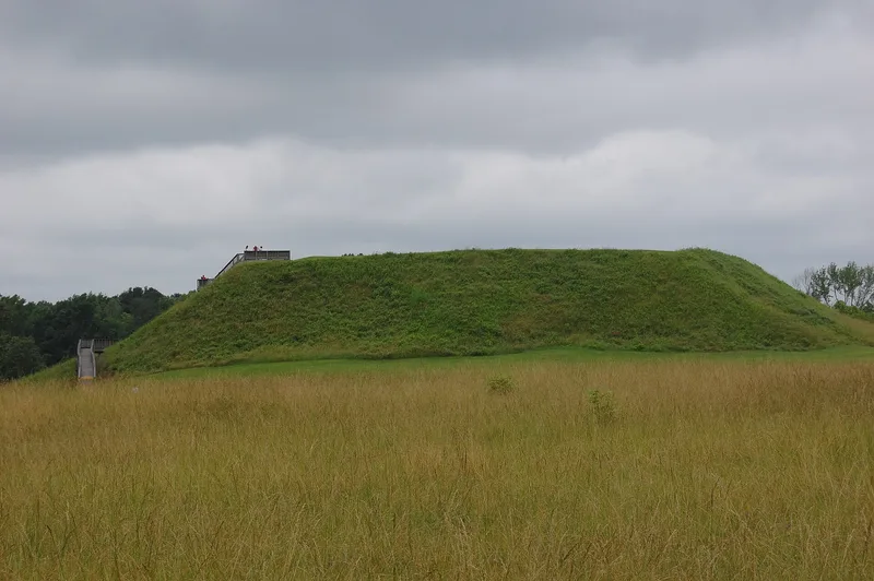
Ocmulgee National Monument preserves a large archeological landscape on a bluff above the Ocmulgee River, east of Macon, Georgia. Seven rectangular Mississippian-period mounds form its core, joined by a separate Lamar area with two later mounds. Excavations in the 1930s recovered over a million pottery and flint artifacts and revealed a sequence of six prehistoric levels of occupation. An earthlodge with a restored clay floor dates to about A.D. 1015. The site also holds the outline of a colonial trading post occupied from roughly 1690 to 1715, the 1856 Dunlap house, and an earthwork tied to the 1864 Stoneman raid on Macon. A 1938 Art Moderne visitor center, decorated with a frieze copied from Lamar pottery, serves as museum, offices and research storage. Smithsonian specialists considered the complex among the most important archeological centers east of the Appalachians, which underlies its protection.
Significance in brief: Smithsonian archeologists who excavated the site in the 1930s judged it one of the most important archeological centers east of the Appalachians, with evidence of about 10,000 years of human use and a chronology still used as a basis for southern prehistory. It also holds a rare colonial trading post site, the Dunlap house and Civil War earthwork, and a visitor center noted for its Art Moderne design.
Machine-generated summary. This summary was generated by a language model from the official nomination document and has not been reviewed line by line by an editor. It may contain errors. Check the source document before relying on any detail. Source: nomination document (PDF) · National Archives catalog entry. NRHP reference 66000099, listed October 15, 1966. Summary generated October 2026 (model claude-sonnet-5-5, prompt v1.0-2026-10-29, confidence medium).
Key facts
| Address | 1207 Emory Hwy., E of Macon, Macon |
|---|---|
| County | Bibb County |
| Listed | October 15, 1966 |
| Reference number | 66000099 |
| Resource type | District |
| Architectural style | Art Moderne (Visitor Center); ante-bellum frame farmhouse (Dunlap House) |
| Areas of significance | Architecture, Historic - Aboriginal, Social History, Religion, Prehistoric, Science, Art |
| Level of significance | National |
| Status (as stated in the nomination) | Publicly owned national monument open to visitors; the mounds are grassed over and accessible by steps, the earthlodge is restored, and the Dunlap House has served as the superintendent's residence. |
| Acreage | 702.1 |
| Coordinates | 32.83238, -83.59172 (NPS GIS) |
What listing means for this property
This is a historic district. Buildings within its boundary are either contributing (they add to the district's significance) or non-contributing. Owners of contributing income-producing buildings can claim the 20% federal rehabilitation tax credit; homeowners should look at state credits. National Register districts impose no design review by themselves; a local historic district ordinance, if one exists, does (the difference explained).
General information, not legal or tax advice. Rules change; confirm with your State Historic Preservation Office or a qualified adviser.
Sources and further reading
- National Park Service, National Register of Historic Places database (snapshot May 2026), reference 66000099.
- Nomination form (PDF, National Archives) — catalog entry
- Wikipedia article (used for cross-checking only; text not reproduced here)
- Wikidata Q1517500
- This listing as JSON
Last updated October 2026. Found an error? See the editorial policy for how to report it.