Kilgore Mill Covered Bridge and Mill Site
Also known as: Bethlehem Bridge; Apalachee River Bridge; Briscoe Mill Bridge

Why it's listed
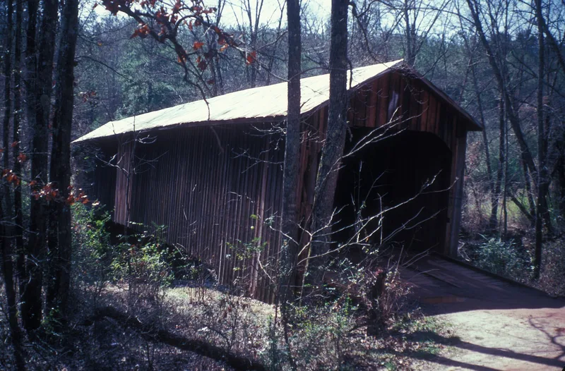
Spanning the Apalachee River on the line between Walton and Barrow counties, this covered bridge is a single 117-foot span built on the Town Lattice design, using rough-sawn pine joined with wooden pins at each intersection. It is 16.5 feet wide, rests on native stone piers, and has a sheet tin roof and plain barn-style portals. The bridge sits beside the site of Kilgore's Mill, where a saw mill and grist mill once operated from a dam just downstream. The land passed through lottery grantees and Joseph James to Willis Kilgore Sr. in 1833, and stayed in the Kilgore family for decades. Only traces of the dam, raceway and stone foundations survive. The bridge was first dated to 1874, but county court minutes later showed that the present structure was built in 1894. It is one of 22 covered bridges left in Georgia, and one of 13 built to the Town Lattice design.
Significance in brief: The bridge is one of 22 covered bridges remaining in Georgia and one of 13 using the Town Lattice truss. The adjoining mill site reflects frontier-era milling in Walton County, tied to the Kilgore family, who held the land for decades. Amendments corrected the bridge's construction date from 1874 to 1894 based on county court records.
Machine-generated summary. This summary was generated by a language model from the official nomination document and has not been reviewed line by line by an editor. It may contain errors. Check the source document before relying on any detail. Source: nomination document (PDF) · National Archives catalog entry. NRHP reference 75000572, listed April 14, 1975. Summary generated October 2026 (model claude-sonnet-5-5, prompt v1.0-2026-10-29, confidence high).
Key facts
| Address | 3.5 mi. SW of Bethlehem across Apalachee River/county line, Bethlehem |
|---|---|
| County | Barrow County |
| Listed | April 14, 1975 |
| Reference number | 75000572 |
| Resource type | Structure |
| Period of significance | 1874 (original form); amended to 1894; 19th Century |
| Architect / builder | Originally credited to D. J. Thompson (1874); amendment documents R. J. Thompson (piers) and other Thompson family suppliers for the 1894 bridge |
| Architectural style | Town Lattice truss covered bridge with plain barn-type portals |
| Areas of significance | Engineering, Transportation, Social History |
| Level of significance | State |
| Status (as stated in the nomination) | Bridge described as structurally good but needing repairs to roof, siding and north approach; still in use for transportation. Mill buildings no longer stand; only remnants of dam, raceway and foundations remain in a wooded area. |
| Acreage | 0.9 |
| Coordinates | 33.90010, -83.74018 (NPS GIS) |
What listing means for this property
For a publicly owned building or structure, listing mainly matters when federal funds, permits or licences are involved: projects then go through Section 106 review so effects on the property are considered. Listing also strengthens applications for preservation grants and, for leased income-producing uses, can enable the federal rehabilitation tax credit.
General information, not legal or tax advice. Rules change; confirm with your State Historic Preservation Office or a qualified adviser.
Sources and further reading
- National Park Service, National Register of Historic Places database (snapshot May 2026), reference 75000572.
- Nomination form (PDF, National Archives) — catalog entry
- Wikipedia article (used for cross-checking only; text not reproduced here)
- Wikidata Q58904098
- This listing as JSON
Last updated October 2026. Found an error? See the editorial policy for how to report it.