Barton-Lackey Cabin
Also known as: Barton Cattle Camp; Lackey Cattle Camp

Why it's listed
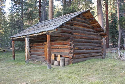
Set on a forested flat at 7,400 feet in Roaring River Canyon, this one-room log cabin at Scaffold Meadow served as a base for a family cattle operation. Hudson DeCamp Barton and his son James DeCamp Barton brought cattle into the region around 1907, seeking high summer pasture for herds that wintered in the Sierra foothills. They built the cabin about 1910. In the early 1920s a Barton daughter married forest ranger Al Lackey, who later took over the business and grazed the range until the canyon became part of Kings Canyon National Park in 1940. A lifetime permit allowed grazing to continue until about 1960. The cabin has a covered porch, a large fireplace, a shaked roof and logs resting directly on the ground. Surrounding outbuildings and fences are gone, and the cabin is badly decayed. It survives as a rare reminder of the cattle trade, and nearby Barton's Peak carries the family name.
Significance in brief: The nomination argues local significance in exploration/settlement and agriculture. The cabin was built by one of the first families to develop a summer grazing range in remote Roaring River Canyon. It is also one of the last surviving remnants of the once important Kings Canyon cattle trade.
Machine-generated summary. This summary was generated by a language model from the official nomination document and has not been reviewed line by line by an editor. It may contain errors. Check the source document before relying on any detail. Source: nomination document (PDF) · National Archives catalog entry. NRHP reference 78000290, listed March 30, 1978. Summary generated October 2026 (model claude-sonnet-5-5, prompt v1.0-2026-10-29, confidence medium).
Key facts
| Address | N of Mineral King in Kings Canyon National Park, Mineral King |
|---|---|
| County | Tulare County |
| Listed | March 30, 1978 |
| Reference number | 78000290 |
| Resource type | Building |
| Period of significance | ca. 1910 |
| Architect / builder | H.D. and J.D. Barton |
| Areas of significance | Exploration/Settlement, Agriculture |
| Level of significance | Local |
| Status (as stated in the nomination) | Deteriorated: wall logs show extensive decay, the structure has settled and the roof has holes. The National Park Service uses it as a storage shed. |
| Acreage | 0.2 |
| Within district | Shorty Lovelace Historic District |
| Coordinates | 36.71266, -118.58409 (NPS GIS) |
What listing means for this property
National Register listing is honorary for a privately owned home: it does not by itself restrict what an owner may do with their own money, and it does not require public access. Restrictions come from local landmark or historic-district ordinances, which are separate (how they differ).
Owner-occupied houses are not eligible for the 20% federal rehabilitation tax credit, which applies to income-producing buildings, but many states offer credits for homeowners. Listing also opens the door to preservation easements and to buying a plaque. Start with what listing means for homeowners, renovating a listed house and selling one.
General information, not legal or tax advice. Rules change; confirm with your State Historic Preservation Office or a qualified adviser.
Sources and further reading
- National Park Service, National Register of Historic Places database (snapshot May 2026), reference 78000290.
- Nomination form (PDF, National Archives) — catalog entry
- Wikipedia article (used for cross-checking only; text not reproduced here)
- Wikidata Q4865578
- This listing as JSON
Last updated October 2026. Found an error? See the editorial policy for how to report it.