Peralta, Luis Maria, Adobe
Also known as: Jose Manual Gonzalez-Luis Maria Peralta Adobe

Why it's listed
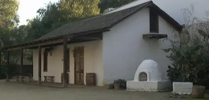
This two-room adobe at 184 West St. John Street in San Jose dates from the 1790s and is described as the last adobe surviving from the first pueblo in Spanish Alta California. It measures about 20 by 41 feet, with walls roughly two feet thick, tamped earth floors and a loft under the roof. José Manuel Gonzalez, an original settler who arrived with the Anza Party in 1776, chose the site on the second pueblo plaza. Luis Maria Peralta, a Spanish colonial soldier who rose to sergeant, is believed to have acquired the house in 1804 and lived there until his death in 1851. Later it served as wine storage. The adobe has been altered only modestly, though its surfaces have cracked and flaked and its south wall has eroded badly. A tie-rod system and protective coverings were added to preserve it. The City of San Jose owns the building.
Significance in brief: The nomination argues it is the last remaining adobe from the first pueblo in Spanish Alta California and a probably rare example of 1790-1800 pioneer domestic architecture in the state. It is also tied to two original owners, José Manuel Gonzalez and Luis Maria Peralta, who came to California with the first Spanish settlers.
Machine-generated summary. This summary was generated by a language model from the official nomination document and has not been reviewed line by line by an editor. It may contain errors. Check the source document before relying on any detail. Source: nomination document (PDF) · National Archives catalog entry. NRHP reference 73000454, listed October 15, 1973. Summary generated October 2026 (model claude-sonnet-5-5, prompt v1.0-2026-10-29, confidence high).
Key facts
| Address | 184 W. St. John St., San Jose |
|---|---|
| County | Santa Clara County |
| Listed | October 15, 1973 |
| Reference number | 73000454 |
| Resource type | Structure |
| Period of significance | after 1797 |
| Areas of significance | Military, Politics/Government, Architecture |
| Level of significance | State |
| Status (as stated in the nomination) | Condition marked fair and altered; wood members show deterioration. A corrugated metal roof and a protective acrylic covering on the south wall were installed in 1973. |
| Acreage | 0.4 |
| Coordinates | 37.33633, -121.89435 (NPS GIS) |
What listing means for this property
National Register listing is honorary: it recognises significance and does not restrict what a private owner may do without federal money or permits. It unlocks the 20% federal rehabilitation tax credit for income-producing buildings, state credits in many states, and Section 106 review when federal agencies are involved. See what listing means in practice.
General information, not legal or tax advice. Rules change; confirm with your State Historic Preservation Office or a qualified adviser.
Sources and further reading
- National Park Service, National Register of Historic Places database (snapshot May 2026), reference 73000454.
- Nomination form (PDF, National Archives) — catalog entry
- Wikipedia article (used for cross-checking only; text not reproduced here)
- Wikidata Q7166894
- This listing as JSON
Last updated October 2026. Found an error? See the editorial policy for how to report it.