San Francisco Bay Discovery Site

Why it's listed
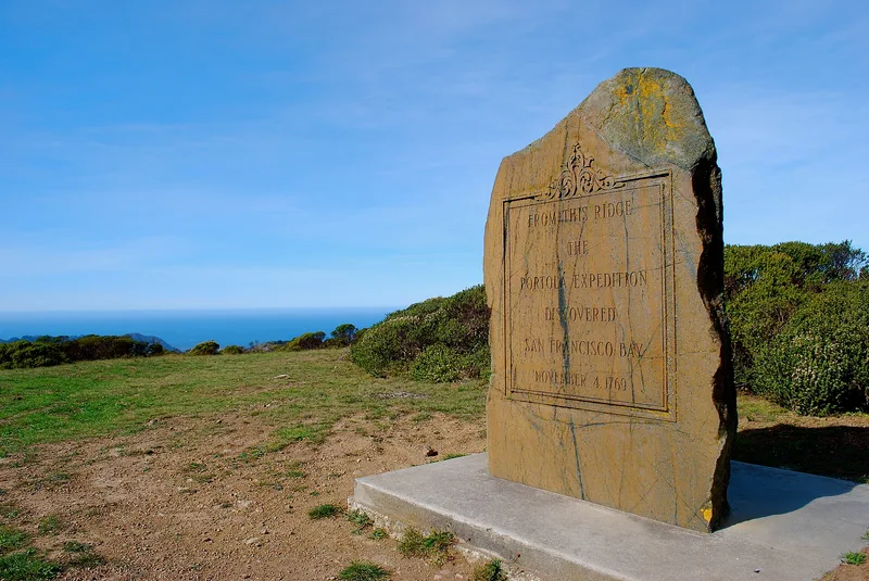
Two knolls on Sweeney Ridge, above Pacifica in San Mateo County, mark the place where the Portola expedition first saw San Francisco Bay in 1769. The nominated area covers about 18.15 acres. No structures stand on it, and none are believed to have stood there before. From the ridge, a viewer can look inland over the bay and north along the coast toward Point Reyes, although industrial and residential development has altered the view. Captain Gaspar de Portola and about sixty men had traveled overland from San Diego looking for Monterey Bay and had not recognized it. After camping in Pedro Valley, the party climbed into the hills on November 4, 1769, and saw the great estuary. The nomination calls the bay the most important harbor on the Pacific Coast and ties its discovery to the Spanish establishment of Alta California. Later expeditions explored the area, and a presidio and missions followed around the bay.
Significance in brief: The nomination argues the site marks the discovery of San Francisco Bay, described as the most important harbor on the Pacific Coast and a major event in establishing the Spanish presence in Alta California. The expedition under Captain Gaspar de Portola had been searching for Monterey Bay when it came upon the bay. The discovery led to later exploration and to the founding of a presidio and missions around the bay.
Machine-generated summary. This summary was generated by a language model from the official nomination document and has not been reviewed line by line by an editor. It may contain errors. Check the source document before relying on any detail. Source: nomination document (PDF) · National Archives catalog entry. NRHP reference 68000022, listed May 23, 1968. Summary generated October 2026 (model claude-sonnet-5-5, prompt v1.0-2026-10-29, confidence medium).
Key facts
| Address | 4 mi. W of San Bruno via Skyline Dr. and Sneath Lane, San Bruno |
|---|---|
| County | San Mateo County |
| Listed | May 23, 1968 |
| Reference number | 68000022 |
| Resource type | Site |
| Period of significance | 1769 |
| Areas of significance | Exploration/Settlement |
| Level of significance | National |
| National Historic Landmark | Yes, designated May 23, 1968 |
| Status (as stated in the nomination) | No structures are on the site. The form lists condition as good and original site, and the land is used for cattle grazing, though the view has changed with urban development around the bay. |
| Acreage | 18.2 |
| Coordinates | 37.60327, -122.45607 (NPS GIS) |
What listing means for this property
Sites (archaeological sites, battlefields, landscapes) are often listed with a restricted address to protect them from looting or disturbance. Listing is honorary for private owners; federal undertakings on or near the site go through Section 106 review, and state laws may protect burials and artefacts regardless of listing.
General information, not legal or tax advice. Rules change; confirm with your State Historic Preservation Office or a qualified adviser.
Sources and further reading
- National Park Service, National Register of Historic Places database (snapshot May 2026), reference 68000022.
- Nomination form (PDF, National Archives) — catalog entry
- Wikipedia article (used for cross-checking only; text not reproduced here)
- Wikidata Q7413934
- This listing as JSON
Last updated October 2026. Found an error? See the editorial policy for how to report it.