Warner's Ranch

Why it's listed
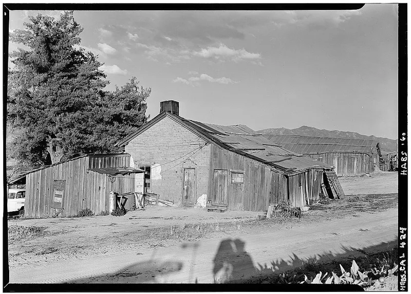
Warner's Ranch is a remnant of a once 44,000-acre ranch in a quiet valley of San Diego County, California. The surviving headquarters includes a one-story adobe ranch house built in 1849 and an adobe barn erected in 1858, both partly covered with weatherboard but intact beneath. Cedar beams, hand-hewn timbers and wooden pegs were used in construction. About a mile east stands a small adobe called Wilson's store, also a wayside stop. Jonathan Trumbull Warner, a Connecticut native who became a Mexican citizen, received the land grants and built the ranch house to trade with arriving pioneers. From 1849 to 1861 the ranch was the first place where emigrants on the Southern route could find food and shelter after the desert crossing. It also served as a Butterfield Overland Mail stage station from 1858 to 1861 and as a cattle ranch. The buildings are badly deteriorated, though shored up and sheathed to slow further decay.
Significance in brief: From 1849 to 1861 the ranch was a famous camping spot and the first place emigrants could find food and shelter after crossing the desert on the Southern emigrant route. It also served as a Butterfield Overland Mail stage station from 1858 to 1861 and was a pioneering American cattle ranch. The surrounding valley has changed little since 1849, and the buildings give an unrestored picture of early conditions in the far west.
Machine-generated summary. This summary was generated by a language model from the official nomination document and has not been reviewed line by line by an editor. It may contain errors. Check the source document before relying on any detail. Source: nomination document (PDF) · National Archives catalog entry. NRHP reference 66000228, listed October 15, 1966. Summary generated October 2026 (model claude-sonnet-5-5, prompt v1.0-2026-10-29, confidence medium).
Key facts
| Address | 4 mi. S of Warner Springs, Warner Springs |
|---|---|
| County | San Diego County |
| Listed | October 15, 1966 |
| Reference number | 66000228 |
| Resource type | Building |
| Period of significance | 1849-1861 |
| Areas of significance | Exploration/Settlement |
| Level of significance | National |
| National Historic Landmark | Yes, designated January 20, 1961 |
| Status (as stated in the nomination) | Buildings are in very poor condition and deteriorated, with crumbling adobe walls protected by board sheathing; being preserved by the Vista Irrigation District with historical societies. Listed as vacant and unoccupied. |
| Acreage | 221 |
| Coordinates | 33.23831, -116.64842 (NPS GIS) |
What listing means for this property
National Register listing is honorary: it recognises significance and does not restrict what a private owner may do without federal money or permits. It unlocks the 20% federal rehabilitation tax credit for income-producing buildings, state credits in many states, and Section 106 review when federal agencies are involved. See what listing means in practice.
Noted as vacant in the nomination. Nomination documents can be decades old; current status may differ. If you are considering buying an empty listed property, read the due-diligence checklist.
General information, not legal or tax advice. Rules change; confirm with your State Historic Preservation Office or a qualified adviser.
Sources and further reading
- National Park Service, National Register of Historic Places database (snapshot May 2026), reference 66000228.
- Nomination form (PDF, National Archives) — catalog entry
- Wikipedia article (used for cross-checking only; text not reproduced here)
- Wikidata Q7969688
- This listing as JSON
Last updated October 2026. Found an error? See the editorial policy for how to report it.