Oak Grove Butterfield Stage Station

Why it's listed
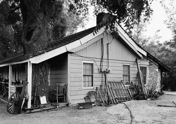
Oak Grove Butterfield Station is a one-story adobe building beside California Route 79, about 13 miles northwest of Warner Springs in San Diego County. Its northern end belongs to the original ranchhouse erected in the 1850s, and later additions have enlarged the structure. The site is listed because it is one of perhaps several stations still standing along the Butterfield Overland Mail route. That service carried mail and passengers from September 1858 to March 1861 over a 2,795-mile course between San Francisco and the eastern termini of St. Louis and Memphis. Way-stations like this one acted as ticket offices and inns, built from whatever material was at hand, including adobe brick. During the Civil War the building served as a hospital for Camp Wright, which occupied ground across the highway. Old oak trees still shade the setting, though sheds, gas pumps and debris surround the building. The northern end remains a residence, and the rest is sometimes used as a store.
Significance in brief: It is one of perhaps several stations still standing along the entire route of the Butterfield Overland Mail, which ran between San Francisco and the eastern termini of St. Louis and Memphis from 1858 to 1861. During the Civil War the building also served as a hospital for nearby Camp Wright.
Machine-generated summary. This summary was generated by a language model from the official nomination document and has not been reviewed line by line by an editor. It may contain errors. Check the source document before relying on any detail. Source: nomination document (PDF) · National Archives catalog entry. NRHP reference 66000222, listed October 15, 1966. Summary generated October 2026 (model claude-sonnet-5-5, prompt v1.0-2026-10-29, confidence medium).
Key facts
| Address | 13 mi. NW of Warner Springs on CA 79, Oak Grove |
|---|---|
| County | San Diego County |
| Listed | October 15, 1966 |
| Reference number | 66000222 |
| Resource type | Building |
| Period of significance | 1858-1861 |
| Areas of significance | Transportation |
| Level of significance | National |
| National Historic Landmark | Yes, designated November 5, 1961 |
| Status (as stated in the nomination) | Described as well preserved and occupied; the northern end is used as a residence and the rest is sometimes used as a general store. Old gas pumps and debris clutter the area around it. |
| Acreage | 0.1 |
| Coordinates | 33.38573, -116.79123 (NPS GIS) |
What listing means for this property
For an income-producing building, listing (individually or as a contributing building in a district) is the gateway to the 20% federal rehabilitation tax credit on qualified rehabilitation costs, often stackable with state credits. Work claiming the credit must follow the Secretary of the Interior's Standards and be approved in advance.
Listing does not restrict a private owner acting without federal money or permits; where federal funding or licensing is involved, Section 106 review applies.
General information, not legal or tax advice. Rules change; confirm with your State Historic Preservation Office or a qualified adviser.
Sources and further reading
- National Park Service, National Register of Historic Places database (snapshot May 2026), reference 66000222.
- Nomination form (PDF, National Archives) — catalog entry
- Wikipedia article (used for cross-checking only; text not reproduced here)
- Wikidata Q7073498
- This listing as JSON
Last updated October 2026. Found an error? See the editorial policy for how to report it.