Euclid Avenue
Also known as: Ca 83

Why it's listed
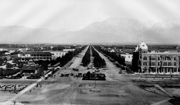
Euclid Avenue is a 200-foot-wide boulevard running about 8.4 miles from the foothills of Mount Baldy at 24th Street in Upland to Philadelphia Street in Ontario. Laid out in 1882 and first planted in 1883, it has two 55-foot drives, a 60-foot landscaped median of California pepper trees, and parkways lined with silk oaks. It was the spine of the Ontario Irrigation Colony, created by brothers George and W.B. Chaffey, and underground pipes beneath it carried water to the colony's parcels. The nomination presents the colony and its Mutual Water Company system as a model for agricultural communities, later copied in Australia. Charles Frankish extended the avenue in 1886. Contributing features include the roadway, the landscape, the Madonna of the Trail monument and two relocated fountains. Several reconstructed items, such as the bandstand and veterans memorial, do not contribute. Freeway and railroad underpasses have altered parts of the route, but the original design remains largely intact.
Significance in brief: The nomination argues the avenue is the best physical example of the planning ideas of George and W.B. Chaffey and their Mutual Water Company model for agricultural colonies, which was later used in Australia. It is cited under community planning and development, social history and landscape architecture. It has also been the center of community events since 1882 and appears in the city seals of Ontario and Upland.
Machine-generated summary. This summary was generated by a language model from the official nomination document and has not been reviewed line by line by an editor. It may contain errors. Check the source document before relying on any detail. Source: nomination document (PDF) · National Archives catalog entry. NRHP reference 05000843, listed August 10, 2005. Summary generated October 2026 (model claude-sonnet-5-5, prompt v1.0-2026-10-29, confidence medium).
Key facts
| Address | From 24th St. in Upland to Philadelphia St. in Ontario, Upland |
|---|---|
| County | San Bernardino County |
| Listed | August 10, 2005 |
| Reference number | 05000843 |
| Resource type | Structure |
| Period of significance | 1882-1940 |
| Architect / builder | Chaffey, George Jr. & William Benjamin (W.B.) Chaffey; Frankish, Charles |
| Architectural style | No style |
| Criteria |
|
| Areas of significance | Community Planning and Development, Social History, Landscape Architecture |
| Level of significance | Local |
| Status (as stated in the nomination) | Still an active state highway and landscaped boulevard. Alterations include freeway and railroad underpasses, replaced curbs and lampposts, and replacement trees, but the nomination says integrity is retained. |
| Acreage | 203 |
| Coordinates | 34.15023, -117.65142 (NPS GIS) |
What listing means for this property
National Register listing is honorary: it recognises significance and does not restrict what a private owner may do without federal money or permits. It unlocks the 20% federal rehabilitation tax credit for income-producing buildings, state credits in many states, and Section 106 review when federal agencies are involved. See what listing means in practice.
General information, not legal or tax advice. Rules change; confirm with your State Historic Preservation Office or a qualified adviser.
Sources and further reading
- National Park Service, National Register of Historic Places database (snapshot May 2026), reference 05000843.
- Nomination form (PDF, National Archives) — catalog entry
- Wikidata Q108145013
- This listing as JSON
Last updated October 2026. Found an error? See the editorial policy for how to report it.