Coloma
Also known as: Coloma (Gold Discovery Site)

Why it's listed
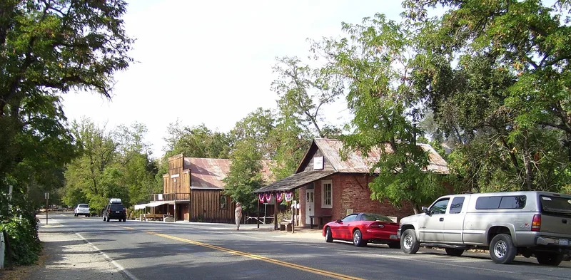
Coloma is a small townsite astride State Route 49 in El Dorado County, California, where the South Fork of the American River flows northwest through town. Today it is part of a state park and holds a few remaining landmarks, deep mining scars half hidden by locust trees, and some cottages with tangled gardens. Several historic buildings survive as stone or brick ruins, while wood frame structures are in various stages of decay. Newer additions include a replica of Sutter's sawmill, a 6,000-square-foot museum, a comfort station with parking, and two residences for park staff. The place matters because James Wilson Marshall found gold here on January 24, 1848, while building a sawmill for John Sutter. That discovery set off the California gold rush. The district takes in the mill site, Marshall's grave and the town, which served as county seat from 1850 to 1857. Its significance has been recognized at the national level.
Significance in brief: The site marks where James Wilson Marshall discovered gold on January 24, 1848, the event that set off the California gold rush. The form calls it of outstanding significance to California and the world, and notes it was named a national historic landmark. Coloma was also the El Dorado County seat from 1850 to 1857.
Machine-generated summary. This summary was generated by a language model from the official nomination document and has not been reviewed line by line by an editor. It may contain errors. Check the source document before relying on any detail. Source: nomination document (PDF) · National Archives catalog entry. NRHP reference 66000207, listed October 15, 1966. Summary generated October 2026 (model claude-sonnet-5-5, prompt v1.0-2026-10-29, confidence medium).
Key facts
| Address | 7 mi. NW of Placerville on CA 49, Placerville |
|---|---|
| County | El Dorado County |
| Listed | October 15, 1966 |
| Reference number | 66000207 |
| Resource type | District |
| Period of significance | 19th Century (specific date January 24, 1848) |
| Areas of significance | Industry, Exploration/Settlement |
| Level of significance | National |
| National Historic Landmark | Yes, designated July 4, 1961 |
| Status (as stated in the nomination) | Condition rated fair and altered. Several historic stone and brick buildings are ruins, and wood frame buildings are deteriorating. Some buildings are kept for residential, interpretive and park use, and preservation work is in progress. |
| Acreage | 112 |
| Coordinates | 38.80056, -120.89174 (NPS GIS) |
What listing means for this property
This is a historic district. Buildings within its boundary are either contributing (they add to the district's significance) or non-contributing. Owners of contributing income-producing buildings can claim the 20% federal rehabilitation tax credit; homeowners should look at state credits. National Register districts impose no design review by themselves; a local historic district ordinance, if one exists, does (the difference explained).
General information, not legal or tax advice. Rules change; confirm with your State Historic Preservation Office or a qualified adviser.
Sources and further reading
- National Park Service, National Register of Historic Places database (snapshot May 2026), reference 66000207.
- Nomination form (PDF, National Archives) — catalog entry
- Wikipedia article (used for cross-checking only; text not reproduced here)
- Wikidata Q1110351
- This listing as JSON
Last updated October 2026. Found an error? See the editorial policy for how to report it.