Moore, Capt. James, Homestead

Why it's listed
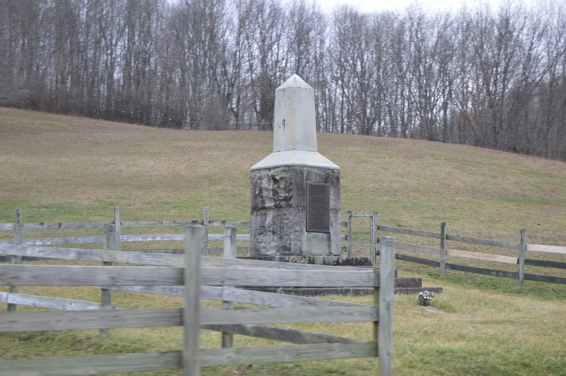
Captain James Moore Homestead is an archaeological site in Abbs Valley, near Boissevain in Tazewell County, Virginia. Captain Moore moved his family there in 1772 to raise livestock, and the farm prospered despite its position near a Shawnee trail. In 1786 Shawnee attackers burned the cabin, an episode well known in local history and marked by a highway marker and a monument erected by descendants in 1928. His son James Moore Jr. later lived on the spot from 1798 to 1822. Archaeological testing in 2000 found two stacked layers of refuse separated by clay fill, containing creamware, pearlware, redware, wrought nails, daub, a brass coin button and fired lead balls. These finds match the Moore occupations and show the site is well preserved. Earlier Native American deposits from the Late Woodland and probably Late Archaic periods lie beneath. The site is listed for its history and its research value on early and late frontier settlement in southwest Virginia.
Significance in brief: The site holds buried deposits from two phases of frontier settlement in southwest Virginia: the original Moore cabin occupation (1772 to the 1786 Shawnee attack and burning) and the later house of James Moore Jr. (1798-1822). Excavation found period ceramics, wrought nails, lead shot and a brass coin button, which indicate a site with a high degree of integrity. A Late Woodland occupation and probable Late Archaic use lie beneath it.
Machine-generated summary. This summary was generated by a language model from the official nomination document and has not been reviewed line by line by an editor. It may contain errors. Check the source document before relying on any detail. Source: nomination document (PDF) · National Archives catalog entry. NRHP reference 02001363, listed November 24, 2002. Summary generated October 2026 (model claude-sonnet-5-5, prompt v1.0-2026-10-29, confidence medium).
Key facts
| Address | VA 644, Boissevain |
|---|---|
| County | Tazewell County |
| Listed | November 24, 2002 |
| Reference number | 02001363 |
| Resource type | Site |
| Period of significance | 1772-1822 |
| Criteria |
|
| Areas of significance | Historic - Non-Aboriginal |
| Level of significance | Local |
| Status (as stated in the nomination) | Private land with a commemorative monument and markers; archaeological testing in 2000 found no architectural features from either the cabin or the later house. |
| Acreage | 4.7 |
| Coordinates | 37.26882, -81.39384 (NPS GIS) |
What listing means for this property
Sites (archaeological sites, battlefields, landscapes) are often listed with a restricted address to protect them from looting or disturbance. Listing is honorary for private owners; federal undertakings on or near the site go through Section 106 review, and state laws may protect burials and artefacts regardless of listing.
General information, not legal or tax advice. Rules change; confirm with your State Historic Preservation Office or a qualified adviser.
Sources and further reading
- National Park Service, National Register of Historic Places database (snapshot May 2026), reference 02001363.
- Nomination form (PDF, National Archives) — catalog entry
- Wikipedia article (used for cross-checking only; text not reproduced here)
- Wikidata Q16851954
- This listing as JSON
Last updated October 2026. Found an error? See the editorial policy for how to report it.