Glebe Church
Also known as: Bennett's Creek Church

Why it's listed
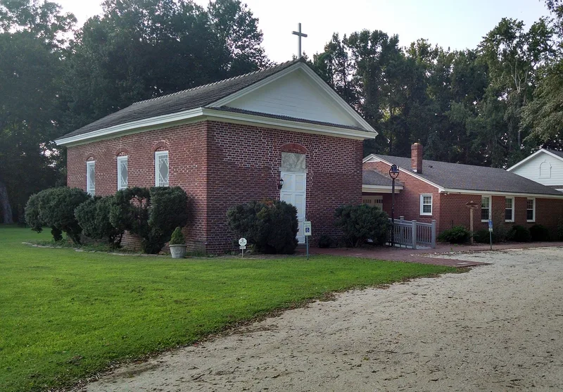
Glebe Church is a brick parish church above the west fork of Bennett's Creek, east of Driver in the former Nansemond County, Virginia. It was built in 1737-1738 after the Virginia Council ruled that the earlier church of the lower parish was too ruinous to keep and ordered a new brick church. It was first known as Bennett's Creek Church. A north wing was added in 1759. After Disestablishment the congregation kept its glebe lands as a private donation, which gave the church its present name. The building stood in ruins until 1856, when the wing was removed and its bricks were used for repairs and a vesting room. The church was reoriented, with the chancel now at the west end, and an east gallery was added. Flemish and English bond brickwork survives, though the interior has no original fabric. It is one of two colonial churches left in the county and still holds its glebe lands.
Significance in brief: It is one of only two colonial churches remaining in Nansemond County. It still holds its original glebe lands, which makes it an important historic rarity. Although altered, it is noted for its fine colonial brickwork.
Machine-generated summary. This summary was generated by a language model from the official nomination document and has not been reviewed line by line by an editor. It may contain errors. Check the source document before relying on any detail. Source: nomination document (PDF) · National Archives catalog entry. NRHP reference 73002148, listed May 25, 1973. Summary generated October 2026 (model claude-sonnet-5-5, prompt v1.0-2026-10-29, confidence high).
Key facts
| Address | W of Chesapeake City on VA 337, Driver (Independent City) |
|---|---|
| County | Suffolk |
| Listed | May 25, 1973 |
| Reference number | 73002148 |
| Resource type | Building |
| Period of significance | 1737-1738 |
| Areas of significance | Architecture, Religion |
| Level of significance | State |
| Status (as stated in the nomination) | Listed in good condition and altered; used as a religious building and occupied. The chancel was moved to the west end, and the interior retains no original fabric. |
| Acreage | 10 |
| Coordinates | 36.82477, -76.49656 (NPS GIS) |
What listing means for this property
Religious properties are listed for their architectural or historical significance, not their religious use. Listing is honorary and does not restrict the congregation's use of the building. The federal rehabilitation credit is generally unavailable unless part of the building is income-producing; some state programmes and preservation grants do cover religious buildings. Federal funding or permits trigger Section 106 review.
General information, not legal or tax advice. Rules change; confirm with your State Historic Preservation Office or a qualified adviser.
Sources and further reading
- National Park Service, National Register of Historic Places database (snapshot May 2026), reference 73002148.
- Nomination form (PDF, National Archives) — catalog entry
- Wikipedia article (used for cross-checking only; text not reproduced here)
- Wikidata Q5567426
- This listing as JSON
Last updated October 2026. Found an error? See the editorial policy for how to report it.