Shenandoah County Farm
Also known as: Shenandoah County Almshouse; Beckford Parish Glebe Farm; 85-86
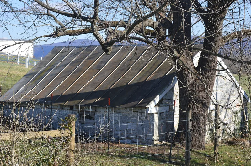

Why it's listed
Built in 1829 near Maurertown, this brick almshouse and its 220-acre farm served as Shenandoah County's home for the poor. The symmetrical building has a two-story central house, once the superintendent's residence, flanked by two 75-foot wings. Each wing holds five one-room apartments. The farm stands on former glebe land of Beckford Parish, and an earlier almshouse occupied the old glebe farmhouse from 1800. Outbuildings include a spring house, a meat house, a barn, and a cemetery with an estimated hundred to two hundred mostly unmarked graves. A 1909 state survey called the institution one of the best in Virginia, and the county declined to join a district home system in 1918. In October 1864 Confederate cavalry camped on the farm before the Battle of Tom's Brook. Listing recognizes its role in local welfare history and its rare, well-preserved Federal institutional design, which continues to serve its original purpose.
Significance in brief: The almshouse was Shenandoah County's main means of caring for the poor for most of its history, which gives it importance in social history. It is also a rare, well-preserved example of an early 19th-century Federal-style institutional building. The farm retains a high degree of architectural and visual integrity.
Machine-generated summary. This summary was generated by a language model from the official nomination document and has not been reviewed line by line by an editor. It may contain errors. Check the source document before relying on any detail. Source: nomination document (PDF) · National Archives catalog entry. NRHP reference 93001122, listed October 29, 1993. Summary generated October 2026 (model claude-sonnet-5-5, prompt v1.0-2026-10-29, confidence high).
Key facts
| Address | N side VA 654, 4000 ft. E of jct. with US 11, Maurertown |
|---|---|
| County | Shenandoah County |
| Listed | October 29, 1993 |
| Reference number | 93001122 |
| Resource type | Building |
| Period of significance | 1829-1943 |
| Architect / builder | Not known |
| Architectural style | Federal |
| Criteria |
|
| Areas of significance | Architecture, Social History, Military |
| Level of significance | State |
| Status (as stated in the nomination) | Still operating as a county farm and almshouse; the fields are leased to a local farmer and the 1991 text reports seven residents. |
| Acreage | 166.4 |
| Coordinates | 38.93260, -78.44514 (NPS GIS) |
What listing means for this property
National Register listing is honorary for a privately owned home: it does not by itself restrict what an owner may do with their own money, and it does not require public access. Restrictions come from local landmark or historic-district ordinances, which are separate (how they differ).
Owner-occupied houses are not eligible for the 20% federal rehabilitation tax credit, which applies to income-producing buildings, but many states offer credits for homeowners. Listing also opens the door to preservation easements and to buying a plaque. Start with what listing means for homeowners, renovating a listed house and selling one.
General information, not legal or tax advice. Rules change; confirm with your State Historic Preservation Office or a qualified adviser.
Sources and further reading
- National Park Service, National Register of Historic Places database (snapshot May 2026), reference 93001122.
- Nomination form (PDF, National Archives) — catalog entry
- Wikipedia article (used for cross-checking only; text not reproduced here)
- Wikidata Q15277138
- This listing as JSON
Last updated October 2026. Found an error? See the editorial policy for how to report it.