Maury Street Marker, Jefferson Davis Highway
Also known as: VDHR File# 127-5833 and 127-6150-0005

Why it's listed
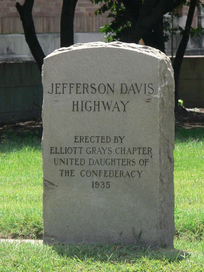
Set in a grassy strip beside U.S. Route 1 in South Richmond, just south of Maury Street, this gray granite slab marks the old Jefferson Davis Highway. The marker stands 45 inches tall, 25 inches wide and 9 inches thick, with smooth faces and rough-cut edges. Its inscription names the highway and credits the Elliott Grays Chapter of the United Daughters of the Confederacy, 1935. The chapter erected it with the support of a Richmond city council resolution that year. It is one of sixteen such markers placed in Virginia between 1927 and 1947 as part of a coast-to-coast memorial route to Confederate president Jefferson Davis, conceived in 1913. The marker is recognized under Criterion A for Transportation and Social History. It reflects the period of privately promoted named highways and a major undertaking by a women's organization. It remains in its original location and keeps its original design and materials, and the chapter still maintains it.
Significance in brief: It is one of sixteen markers placed in Virginia between 1927 and 1947 by the United Daughters of the Confederacy along the Jefferson Davis Highway, a cross-country memorial route. The nomination argues it meets Criterion A in Transportation and Social History, through its tie to the era of named highways (1913-1925) and as an achievement of a women's organization. It is treated as having statewide significance under the related multiple property listing.
Machine-generated summary. This summary was generated by a language model from the official nomination document and has not been reviewed line by line by an editor. It may contain errors. Check the source document before relying on any detail. Source: nomination document (PDF) · National Archives catalog entry. NRHP reference 04000572, listed June 2, 2004. Summary generated October 2026 (model claude-sonnet-5-5, prompt v1.0-2026-10-29, confidence high).
Key facts
| Address | Jct. of Maury St. and Jefferson Davis Highway, Richmond (Independent City) |
|---|---|
| County | Richmond (city and county) |
| Listed | June 2, 2004 |
| Reference number | 04000572 |
| Resource type | Object |
| Period of significance | 1913-1947 |
| Criteria |
|
| Areas of significance | Transportation, Social History |
| Level of significance | State |
| Status (as stated in the nomination) | Retains its original location and integrity; the local UDC chapter continues to maintain it. |
| Acreage | 0.9 |
| Coordinates | 37.51273, -77.44833 (NPS GIS) |
What listing means for this property
National Register listing is honorary: it recognises significance and does not restrict what a private owner may do without federal money or permits. It unlocks the 20% federal rehabilitation tax credit for income-producing buildings, state credits in many states, and Section 106 review when federal agencies are involved. See what listing means in practice.
General information, not legal or tax advice. Rules change; confirm with your State Historic Preservation Office or a qualified adviser.
Sources and further reading
- National Park Service, National Register of Historic Places database (snapshot May 2026), reference 04000572.
- Nomination form (PDF, National Archives) — catalog entry
- Wikipedia article (used for cross-checking only; text not reproduced here)
- Wikidata Q16894791
- This listing as JSON
Last updated October 2026. Found an error? See the editorial policy for how to report it.