Zoar
Also known as: Mount Zoar; Upper Zoar; Lower Zoar; Zoar State Park; 050-0119

Why it's listed
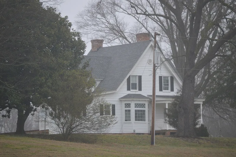
Zoar is a farmstead of 327.75 acres on a hill above the town of Aylett in King William County, Virginia, near the Mattaponi River. Its centerpiece is a one-and-one-half-story Queen Anne farmhouse built in 1901 to replace an earlier house that burned. The house has an irregular plan, bands of square-cut and diamond-cut shingles, and canted and squared bays. Behind it, outbuildings form a courtyard farm plan: a dairy, a kitchen and servants' quarters, a smokehouse, a crib and a barn. A brick-walled family cemetery holds gravestones of the Pollard family, who lived at the farm. A historic field south of the house is still cultivated, while western lands are forested. The property is significant for agriculture and architecture between 1821 and 1957. Its Queen Anne house is unusual among rural Virginia farmhouses, and the farm layout shows a typical courtyard plan. The Department of Forestry acquired the land in 1987.
Significance in brief: The nomination argues Zoar qualifies under Criteria A and C as an agricultural property and for its architectural design. It retains a courtyard-plan farmstead with outbuildings from the 1820s onward. Its 1901 Queen Anne farmhouse is a rare high-style rural example in an area where the style is mostly found in towns.
Machine-generated summary. This summary was generated by a language model from the official nomination document and has not been reviewed line by line by an editor. It may contain errors. Check the source document before relying on any detail. Source: nomination document (PDF) · National Archives catalog entry. NRHP reference 06000065, listed June 22, 2007. Summary generated October 2026 (model claude-sonnet-5-5, prompt v1.0-2026-10-29, confidence medium).
Key facts
| Address | VA 608, Upshaw Rd., Aylett |
|---|---|
| County | King William County |
| Listed | June 22, 2007 |
| Reference number | 06000065 |
| Resource type | District |
| Period of significance | 1821-1957 |
| Architectural style | Mid-19th Century; Late Victorian: Queen Anne |
| Criteria |
|
| Areas of significance | Architecture, Agriculture |
| Level of significance | Local |
| Status (as stated in the nomination) | Owned by the state and used as a state forest; the Department of Forestry added two non-contributing buildings after acquiring it in 1987. Fields south of the house are still cultivated. |
| Acreage | 327.8 |
| Coordinates | 37.79587, -77.11568 (NPS GIS) |
What listing means for this property
This is a historic district. Buildings within its boundary are either contributing (they add to the district's significance) or non-contributing. Owners of contributing income-producing buildings can claim the 20% federal rehabilitation tax credit; homeowners should look at state credits. National Register districts impose no design review by themselves; a local historic district ordinance, if one exists, does (the difference explained).
General information, not legal or tax advice. Rules change; confirm with your State Historic Preservation Office or a qualified adviser.
Sources and further reading
- National Park Service, National Register of Historic Places database (snapshot May 2026), reference 06000065.
- Nomination form (PDF, National Archives) — catalog entry
- Wikipedia article (used for cross-checking only; text not reproduced here)
- Wikidata Q8073167
- This listing as JSON
Last updated October 2026. Found an error? See the editorial policy for how to report it.