High Bridge
Also known as: #024-0056; High Bridge Trail State Park; #006-5007-0002

Why it's listed
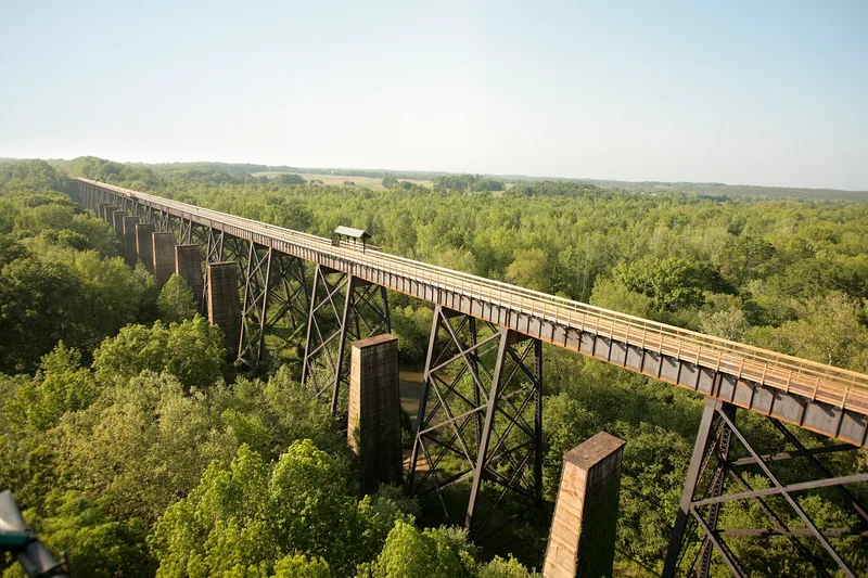
High Bridge is a sixteen-acre district on a former rail line east of Farmville, where two bridges cross the Appomattox River flood plain. The first, built in 1854 for the South Side Railroad, was a timber Burr-arch truss carried on brick piers with granite and sandstone abutments. At 2,400 feet long and up to 125 feet high, it was among the largest bridges in the world in its day. Its wooden superstructure is gone, but both abutments and thirteen brick piers survive. Beside it stands the 1914 steel plate-girder trestle, 2,418 feet long on twenty-one steel towers, built by the Virginia Bridge and Iron Company. The site matters for its role in Virginia's railroad network and for Civil War events, including the 1865 fighting as Confederate forces retreated west. It also shows the change from timber and masonry to steel in bridge building. The old rail corridor is now a pedestrian park.
Significance in brief: The nomination cites its link to Virginia railroad development from the mid-1800s to the early 1900s and to major Civil War events, including the 1865 Battle of High Bridge. It also argues the two bridges show the shift from traditional timber and masonry construction to modern steel bridge engineering.
Machine-generated summary. This summary was generated by a language model from the official nomination document and has not been reviewed line by line by an editor. It may contain errors. Check the source document before relying on any detail. Source: nomination document (PDF) · National Archives catalog entry. NRHP reference 08000875, listed September 12, 2008. Summary generated October 2026 (model claude-sonnet-5-5, prompt v1.0-2026-10-29, confidence medium).
Key facts
| Address | Appomattox River, Farmville |
|---|---|
| County | Cumberland County |
| Listed | September 12, 2008 |
| Reference number | 08000875 |
| Resource type | District |
| Period of significance | 1854-1914 |
| Architect / builder | Virginia Bridge and Iron Company |
| Architectural style | No Style |
| Criteria |
|
| Areas of significance | Engineering, Military, Transportation |
| Level of significance | State |
| Status (as stated in the nomination) | The 1854 bridge has lost its wooden superstructure and several piers, though the abutments and thirteen piers remain stable. The 1914 bridge is in very good condition, with only the rails removed. The site is now used as a pedestrian park. |
| Acreage | 16 |
| Coordinates | 37.31401, -78.31938 (NPS GIS) |
What listing means for this property
This is a historic district. Buildings within its boundary are either contributing (they add to the district's significance) or non-contributing. Owners of contributing income-producing buildings can claim the 20% federal rehabilitation tax credit; homeowners should look at state credits. National Register districts impose no design review by themselves; a local historic district ordinance, if one exists, does (the difference explained).
General information, not legal or tax advice. Rules change; confirm with your State Historic Preservation Office or a qualified adviser.
Sources and further reading
- National Park Service, National Register of Historic Places database (snapshot May 2026), reference 08000875.
- Nomination form (PDF, National Archives) — catalog entry
- Wikipedia article (used for cross-checking only; text not reproduced here)
- Wikidata Q4030901
- This listing as JSON
Last updated October 2026. Found an error? See the editorial policy for how to report it.