Sunray Agricultural Historic District
Also known as: Sunray Village

The pin is a point inside the NPS boundary polygon, not a surveyed location.
Why it's listed
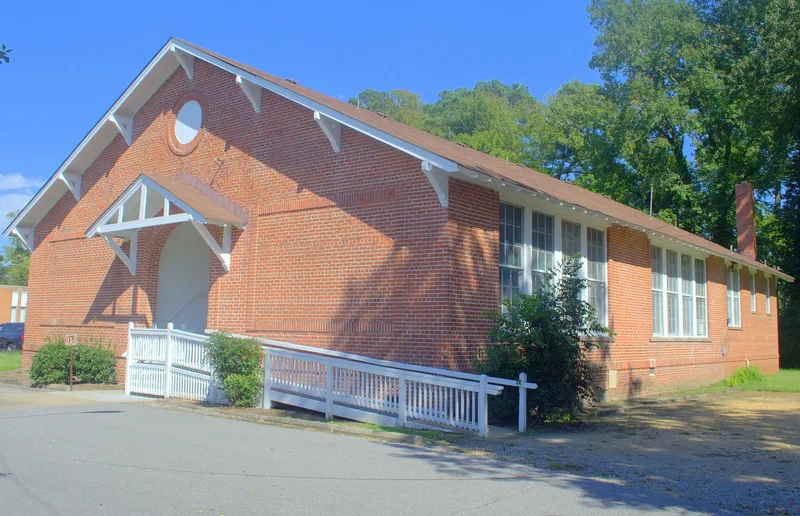
Sunray is a planned farming community in Chesapeake, Virginia, laid out in 1908 by the Southern Homestead Company between the Great Dismal Swamp and what is now Interstate 64. Rectangular fields run north to south and are divided by handmade brackish-water tidal ditches and paved roads. Early 20th century farmhouses sit about twenty-five feet back from the roads, with barns and sheds clustered nearby. At the entrance, where the road meets the abandoned Virginian Railroad tracks, stand St. Mary's Catholic Church, built in 1915-1916 in Gothic Revival style, and a brick Craftsman-style school from 1922 built to a state standard design. Carpenter Michale Pavlovetz built an ornate house on Homestead Avenue and helped neighbors build theirs. Mid-century ranch and Colonial Revival houses were added on subdivided plots without disturbing the original layout. The district is recognized for its agriculture, community planning and immigrant heritage between 1908 and 1956.
Significance in brief: The district is significant for agriculture, community planning and development, and ethnic heritage as an early 20th century immigrant farming community. Its grid of rectangular fields divided by tidal ditches follows the original 1908 plat, and it keeps its farmhouses, outbuildings, church and school. The period of significance runs from 1908 to 1956.
Machine-generated summary. This summary was generated by a language model from the official nomination document and has not been reviewed line by line by an editor. It may contain errors. Check the source document before relying on any detail. Source: nomination document (PDF) · National Archives catalog entry. NRHP reference 03000564, listed May 29, 2007. Summary generated October 2026 (model claude-sonnet-5-5, prompt v1.0-2026-10-29, confidence high).
Key facts
| Address | Roughly bounded by Great Dismal Swamp & I 64, Chesapeake |
|---|---|
| County | Chesapeake |
| Listed | May 29, 2007 |
| Reference number | 03000564 |
| Resource type | District |
| Period of significance | 1908-1956 |
| Architect / builder | Michale Pavlovetz, carpenter; Virginia State Board of Education |
| Architectural style | Late 19th and 20th Century Revivals (Colonial Revival, Late Gothic Revival); Bungalow/Craftsman; Modern Movement: Other |
| Criteria |
|
| Areas of significance | Agriculture, Community Planning and Development, European |
| Level of significance | Local |
| Status (as stated in the nomination) | The district is described as retaining its integrity. The Virginian Railroad tracks are abandoned, and some farm outbuildings are deteriorating. The fields are still farmed, mainly in soybeans and flowering bulbs, and the houses are still used as dwellings. |
| Acreage | 1264 |
| Coordinates | 36.77244, -76.41919 (NPS GIS) |
What listing means for this property
This is a historic district. Buildings within its boundary are either contributing (they add to the district's significance) or non-contributing. Owners of contributing income-producing buildings can claim the 20% federal rehabilitation tax credit; homeowners should look at state credits. National Register districts impose no design review by themselves; a local historic district ordinance, if one exists, does (the difference explained).
General information, not legal or tax advice. Rules change; confirm with your State Historic Preservation Office or a qualified adviser.
Sources and further reading
- National Park Service, National Register of Historic Places database (snapshot May 2026), reference 03000564.
- Nomination form (PDF, National Archives) — catalog entry
- Wikipedia article (used for cross-checking only; text not reproduced here)
- Wikidata Q16900927
- This listing as JSON
Last updated October 2026. Found an error? See the editorial policy for how to report it.