Stanton Family Cemetery
Also known as: DHR File No. 14-52
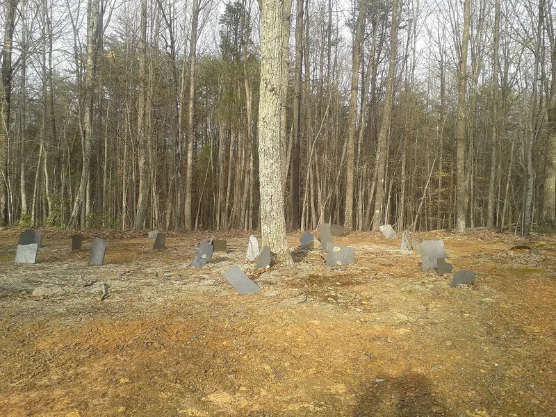

Why it's listed
This small family burial ground in northeastern Buckingham County, Virginia, holds at least 36 graves in six irregular rows, all oriented east-west. Most are marked with rough slabs of local Buckingham slate, which are almost entirely uninscribed; fieldstones mark eight graves and marble military stones mark three World War I veterans. The cemetery began in 1853, when Nancy Stanton, who with her husband Daniel had bought 46.5 acres that year, became the first known person buried there. The Stantons were free black landholders, and later generations worked as farmers, boatmen, carpenters and slate quarrymen. The cemetery was listed because it represents free black history in rural Virginia. Antebellum resources of this kind are uncommon, and few such cemeteries were established by free blacks on their own land. It has kept its original markers, rural setting and layout. A commemorative slate slab to Daniel and Nancy Stanton, placed later at the entrance, is the only major later addition.
Significance in brief: The nomination argues the cemetery is a rare, well-preserved antebellum burial ground created by free blacks on their own land rather than on a plantation. It reflects the economic and social standing of the Stanton family and the history of rural free blacks in Virginia. Its uninscribed local slate markers and high integrity make it a rare resource at the local and state levels.
Machine-generated summary. This summary was generated by a language model from the official nomination document and has not been reviewed line by line by an editor. It may contain errors. Check the source document before relying on any detail. Source: nomination document (PDF) · National Archives catalog entry. NRHP reference 93000350, listed April 29, 1993. Summary generated October 2026 (model claude-sonnet-5-5, prompt v1.0-2026-10-29, confidence high).
Key facts
| Address | VA 677 E side, 0.4 mi. N of jct. with VA 676, Diana Mills |
|---|---|
| County | Buckingham County |
| Listed | April 29, 1993 |
| Reference number | 93000350 |
| Resource type | Site |
| Period of significance | 1853-1941 |
| Architectural style | No style |
| Criteria |
|
| Areas of significance | Black |
| Level of significance | Local |
| Status (as stated in the nomination) | Recently cleared of volunteer vegetation; no fence, little disturbance and no apparent vandalism. The nearby family house site survives only as foundations and is excluded from the boundary. |
| Acreage | 1 |
| Coordinates | 37.65631, -78.39483 (NPS GIS) |
What listing means for this property
Sites (archaeological sites, battlefields, landscapes) are often listed with a restricted address to protect them from looting or disturbance. Listing is honorary for private owners; federal undertakings on or near the site go through Section 106 review, and state laws may protect burials and artefacts regardless of listing.
General information, not legal or tax advice. Rules change; confirm with your State Historic Preservation Office or a qualified adviser.
Sources and further reading
- National Park Service, National Register of Historic Places database (snapshot May 2026), reference 93000350.
- Nomination form (PDF, National Archives) — catalog entry
- Wikipedia article (used for cross-checking only; text not reproduced here)
- Wikidata Q14713254
- This listing as JSON
Last updated October 2026. Found an error? See the editorial policy for how to report it.