Galveston Causeway

Why it's listed
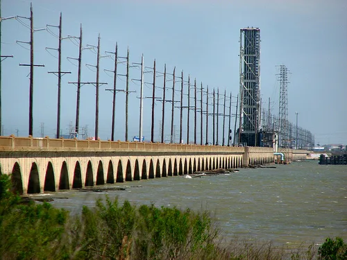
Spanning Galveston Bay between Virginia Point and Galveston Island, this causeway was built from 1909 to 1912 by Galveston County and a group of railway companies. It originally combined earthen embankments, 28 reinforced concrete arches and a steel Scherzer rolling lift drawbridge, then the largest of its type in the world. The structure carried a county highway, electric interurban tracks and steam railroad tracks, and it also enclosed a 30-inch fresh water main. The 1915 hurricane washed out most of the earthen approaches, leaving the arch and draw sections standing. Reconstruction from 1917 to 1922 replaced the embankments with concrete arches, producing the continuous arched bridge seen today, with 51 arches on the mainland end and 28 on the island end. Before it opened, a single-track trestle was the only connection to the mainland, which limited commerce. The causeway was listed as the first successful bridge across Galveston Bay and continues to carry rail traffic.
Significance in brief: The nomination argues it was the first successful bridge across Galveston Bay and the first reliable transportation and communications link between Galveston and the mainland. It carried rail, interurban and highway traffic and a fresh water main, supporting the city's port commerce after the 1900 hurricane. Its Scherzer rolling lift span was the largest of its kind in the world in 1912.
Machine-generated summary. This summary was generated by a language model from the official nomination document and has not been reviewed line by line by an editor. It may contain errors. Check the source document before relying on any detail. Source: nomination document (PDF) · National Archives catalog entry. NRHP reference 76002028, listed December 12, 1976. Summary generated October 2026 (model claude-sonnet-5-5, prompt v1.0-2026-10-29, confidence high).
Key facts
| Address | Spans Galveston Bay from Virginia Point to Galveston Island, Galveston |
|---|---|
| County | Galveston County |
| Listed | December 12, 1976 |
| Reference number | 76002028 |
| Resource type | Structure |
| Period of significance | 1900- |
| Architect / builder | Designed by the Concrete Steel Engineering Co., New York; concrete and earth portion built by A.M. Blodgett Construction Co., Kansas City, Mo.; steel draw span built by Penn Bridge Co., Beaver Falls, Penn. |
| Areas of significance | Industry, Commerce, Economics, Engineering, Transportation, Communications, Social History |
| Level of significance | Local |
| Status (as stated in the nomination) | Still in use for railroad traffic; the old county highway portion serves as a railroad service road. |
| Acreage | 39 |
| Coordinates | 29.30031, -94.89233 (NPS GIS) |
What listing means for this property
National Register listing is honorary: it recognises significance and does not restrict what a private owner may do without federal money or permits. It unlocks the 20% federal rehabilitation tax credit for income-producing buildings, state credits in many states, and Section 106 review when federal agencies are involved. See what listing means in practice.
General information, not legal or tax advice. Rules change; confirm with your State Historic Preservation Office or a qualified adviser.
Sources and further reading
- National Park Service, National Register of Historic Places database (snapshot May 2026), reference 76002028.
- Nomination form (PDF, National Archives) — catalog entry
- Wikipedia article (used for cross-checking only; text not reproduced here)
- Wikidata Q5519420
- This listing as JSON
Last updated October 2026. Found an error? See the editorial policy for how to report it.