Fort Lancaster

Why it's listed
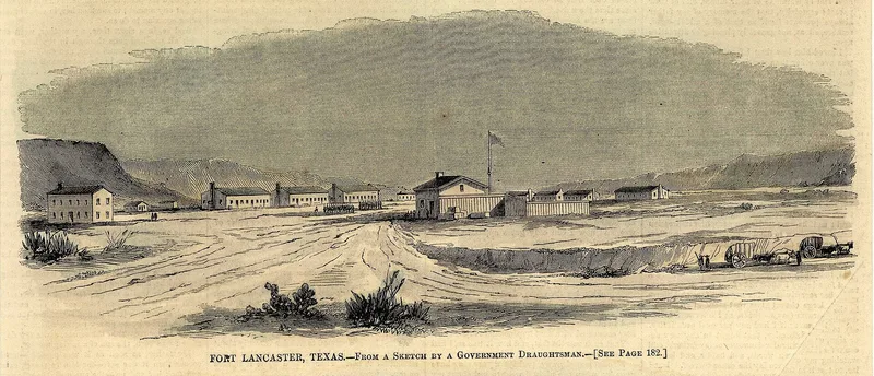
Fort Lancaster is a ruined frontier military post in the Pecos River Valley of Crockett County, Texas, about 10 miles east of Sheffield. Established in August 1855, it was one of several forts built along the western Texas frontier as settlement spread. Its job was to protect settlers and travelers heading between Texas and California, and it guarded the Pecos crossing on the Lower Road between San Antonio and El Paso, the route used by the stage. Early buildings were crude portable shelters, but by 1860 most were stone or adobe. The Federal post was abandoned in 1861 when Texas seceded, served briefly as a Confederate garrison from December 1861 to April 1862, and was reactivated in 1871 as a sub-post during the Kiowa-Comanche uprising. It was abandoned for good around 1873 or 1874. Today the remains include ruins of 29 buildings, a lime kiln, a cemetery and trash dumps, with some walls six to ten feet high and a prominent barrack chimney. The state now owns the site.
Significance in brief: Fort Lancaster was one of a series of forts built along the western Texas frontier to protect settlers and travelers going between Texas and California. It sat at the Pecos crossing on the Lower Road between San Antonio and El Paso, used by the stage. It is significant for its military and transportation roles.
Machine-generated summary. This summary was generated by a language model from the official nomination document and has not been reviewed line by line by an editor. It may contain errors. Check the source document before relying on any detail. Source: nomination document (PDF) · National Archives catalog entry. NRHP reference 71000928, listed March 11, 1971. Summary generated October 2026 (model claude-sonnet-5-5, prompt v1.0-2026-10-29, confidence high).
Key facts
| Address | 10 mi. E of Sheffield on U.S. 290, Sheffield |
|---|---|
| County | Crockett County |
| Listed | March 11, 1971 |
| Reference number | 71000928 |
| Resource type | Site |
| Period of significance | 1855-1860 |
| Areas of significance | Military, Transportation |
| Level of significance | State |
| Status (as stated in the nomination) | Stands in ruins on state-owned land; a museum had recently been built and was about to open as the site was being developed. |
| Acreage | 39 |
| Coordinates | 30.66643, -101.69651 (NPS GIS) |
What listing means for this property
Sites (archaeological sites, battlefields, landscapes) are often listed with a restricted address to protect them from looting or disturbance. Listing is honorary for private owners; federal undertakings on or near the site go through Section 106 review, and state laws may protect burials and artefacts regardless of listing.
General information, not legal or tax advice. Rules change; confirm with your State Historic Preservation Office or a qualified adviser.
Sources and further reading
- National Park Service, National Register of Historic Places database (snapshot May 2026), reference 71000928.
- Nomination form (PDF, National Archives) — catalog entry
- Wikipedia article (used for cross-checking only; text not reproduced here)
- Wikidata Q5471452
- This listing as JSON
Last updated October 2026. Found an error? See the editorial policy for how to report it.