San Antonio City Cemeteries Historic District, Old
Also known as: Eastside Cemetery Historic District

Why it's listed
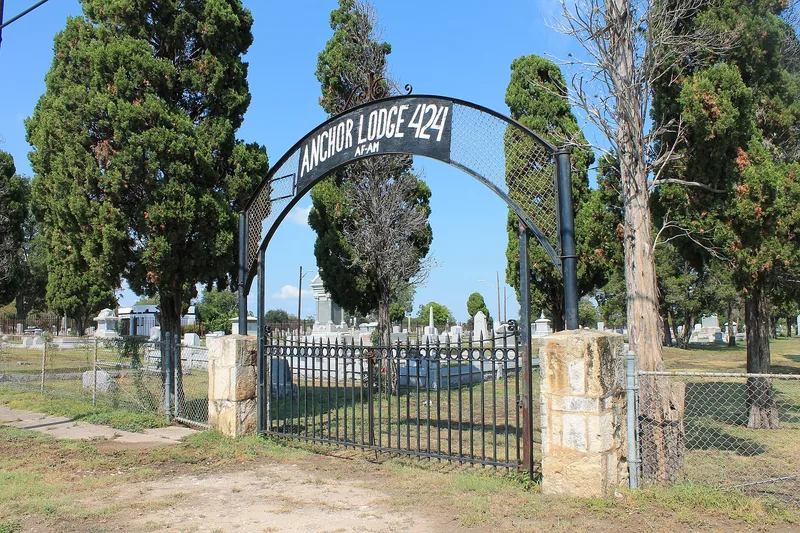
Thirty-one adjoining cemeteries spread across 103 acres about 1.5 miles east of San Antonio's City Hall, on land the King of Spain deeded to the city in 1733. Founded between 1853 and 1904, they were begun by the city, churches and synagogues, religious and fraternal orders, families, the federal government and the United Confederate Veterans. East Commerce Street divides them into northern and southern sectors. Most graves lie in north-south rows with markers facing east, following a southern folk tradition. Small granite, marble and limestone markers predominate, with occasional mausoleums, statuary, walls and gateposts, including work by sculptors Pompeo Coppini and Frank Teich. Roughly 70 percent of burials date before 1949. The grounds are significant as a record of the people who shaped San Antonio, including German immigrants, Jewish congregations, Confederate veterans, African American residents and fraternal groups. Vandalism, theft and neglect have damaged many plots, but the district keeps enough integrity to convey its history.
Significance in brief: The nomination argues the cemeteries together record the early development of San Antonio and the diverse city, religious, fraternal, ethnic and military groups that buried their dead there. They qualify under Criterion A for that history and under Criterion C for their monuments, mausoleums, boundaries and circulation systems, with a period of significance of 1853-1949. Each cemetery is considered to retain enough integrity despite decay and vandalism.
Machine-generated summary. This summary was generated by a language model from the official nomination document and has not been reviewed line by line by an editor. It may contain errors. Check the source document before relying on any detail. Source: nomination document (PDF) · National Archives catalog entry. NRHP reference 00000772, listed October 11, 2000. Summary generated October 2026 (model claude-sonnet-5-5, prompt v1.0-2026-10-29, confidence medium).
Key facts
| Address | Roughly bounded by Nevada, New Braunfels, Paso Hondo, Palmetto, Potomac, St. James, Pine, E. Commerce, Dakota, Monumenta, San Antonio |
|---|---|
| County | Bexar County |
| Listed | October 11, 2000 |
| Reference number | 00000772 |
| Resource type | District |
| Period of significance | 1853-1949 |
| Architectural style | No style |
| Criteria |
|
| Areas of significance | Community Planning and Development, Art |
| Level of significance | Local |
| Status (as stated in the nomination) | Cemeteries are still considered active with only occasional burials. Many have suffered decay, vandalism, toppled stones and missing fencing. The City maintains eight, and six appear abandoned. |
| Acreage | 103 |
| Coordinates | 29.41923, -98.46466 (NPS GIS) |
What listing means for this property
This is a historic district. Buildings within its boundary are either contributing (they add to the district's significance) or non-contributing. Owners of contributing income-producing buildings can claim the 20% federal rehabilitation tax credit; homeowners should look at state credits. National Register districts impose no design review by themselves; a local historic district ordinance, if one exists, does (the difference explained).
General information, not legal or tax advice. Rules change; confirm with your State Historic Preservation Office or a qualified adviser.
Sources and further reading
- National Park Service, National Register of Historic Places database (snapshot May 2026), reference 00000772.
- Nomination form (PDF, National Archives) — catalog entry
- Wikipedia article (used for cross-checking only; text not reproduced here)
- Wikidata Q108661041
- This listing as JSON
Last updated October 2026. Found an error? See the editorial policy for how to report it.