Frankford Arsenal
Also known as: US Arsenal at Frankford

Why it's listed
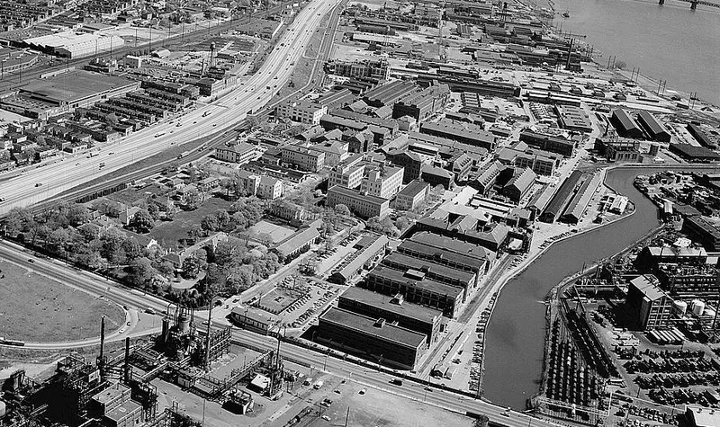
Frankford Arsenal sits on a tract in northeast Philadelphia that the federal government acquired in 1816, after Congress authorized a network of munitions depots in 1815. Its early buildings include stone and brick storehouses, officers' quarters and a commandant's residence dating from 1812 to 1823, several of them with stucco finishes and cast iron verandas. The West Storehouse, built in 1817, is recorded as the site where President Madison officiated at the laying of the cornerstone. Embedded in its west wall are cannon barrels, two of which were surrendered by Burgoyne at Saratoga in 1777. The arsenal developed into a center for explosives testing in the late nineteenth century and later for optical and fire control research, including work on anti-aircraft devices. Its early reinforced concrete buildings, first used in 1901, are cited as a notable group of construction types from that period of innovation.
Significance in brief: The nomination argues the arsenal is significant for its role in military munitions manufacture, its 19th-century storage and production functions, and its later development of explosives testing, optics and fire control research. It also cites early reinforced concrete construction at the site beginning in 1901 as an important collection of early construction types.
Machine-generated summary. This summary was generated by a language model from the official nomination document and has not been reviewed line by line by an editor. It may contain errors. Check the source document before relying on any detail. Source: nomination document (PDF) · National Archives catalog entry. NRHP reference 72001153, listed March 16, 1972. Summary generated October 2026 (model claude-haiku-5-5, prompt v1.1-2026-10-29, confidence medium).
Key facts
| Address | Tacony and Bridge Sts., Philadelphia |
|---|---|
| County | Philadelphia |
| Listed | March 16, 1972 |
| Reference number | 72001153 |
| Resource type | District |
| Areas of significance | Military, Engineering, Science, Invention |
| Level of significance | National |
| Status (as stated in the nomination) | Active installation; Section E lists the status as active. |
| Acreage | 99.4 |
| Coordinates | 40.00751, -75.06305 (NPS GIS) |
What listing means for this property
This is a historic district. Buildings within its boundary are either contributing (they add to the district's significance) or non-contributing. Owners of contributing income-producing buildings can claim the 20% federal rehabilitation tax credit; homeowners should look at state credits. National Register districts impose no design review by themselves; a local historic district ordinance, if one exists, does (the difference explained).
General information, not legal or tax advice. Rules change; confirm with your State Historic Preservation Office or a qualified adviser.
Sources and further reading
- National Park Service, National Register of Historic Places database (snapshot May 2026), reference 72001153.
- Nomination form (PDF, National Archives) — catalog entry
- Wikipedia article (used for cross-checking only; text not reproduced here)
- Wikidata Q1357068
- This listing as JSON
Last updated October 2026. Found an error? See the editorial policy for how to report it.