Lupfer, Israel and Samuel, Tannery Site and House
Also known as: Monterey Tannery

Why it's listed
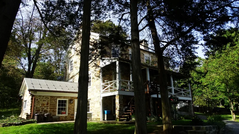
Along Shaeffer Run in Toboyne Township, Perry County, lie the buried and partly visible remains of a tannery operated by Israel and Samuel Lupfer from 1848 until the late nineteenth century. The visible foundations of four large ground pits, a walkway and a raceway roughly measure 104 by 166 feet, and the steam boiler stood at the south corner of the site. Workers' housing, a bark preparation house and a cook house survive below ground. Beside the road stands the Lupfer residence, built in 1852 of stone, with a four-room vernacular plan associated with the Pennsylvania German community, a cooking fireplace with crane, and original six-over-six sash and paneled doors. Israel Lupfer sold both tannery properties in 1878. The 1850 and 1860 manufacture censuses record the tannery's hides, workforce and output. The site is regarded as significant for its largely unaltered archaeological evidence of a small rural tanning works, a building type rarely surviving in the region.
Significance in brief: The nomination argues the property is significant for its role in Perry County's tanning industry and for the substantial archaeological remains of the tannery, which are said to be unusually well preserved. The site is presented as able to yield information on how mid-to-late nineteenth-century Pennsylvania tanneries operated and how their workers lived.
Machine-generated summary. This summary was generated by a language model from the official nomination document and has not been reviewed line by line by an editor. It may contain errors. Check the source document before relying on any detail. Source: nomination document (PDF) · National Archives catalog entry. NRHP reference 03000493, listed May 30, 2003. Summary generated October 2026 (model claude-haiku-5-5, prompt v1.1-2026-10-29, confidence high).
Key facts
| Address | Black Hollow Rd., SW of Toboyne/Jackson Townships, Toboyne |
|---|---|
| County | Perry County |
| Listed | May 30, 2003 |
| Reference number | 03000493 |
| Resource type | Site |
| Period of significance | 1848-ca.1900 |
| Criteria |
|
| Areas of significance | Industry, Historic - Non-Aboriginal |
| Level of significance | Local |
| Status (as stated in the nomination) | The archaeological remains are visible above ground in late fall, winter and early spring; the residence is retained, and a three-car stone garage (ca. 1930) and a late-twentieth-century frame outbuilding are noncontributing. The Commonwealth of Pennsylvania owned the property from 1917 until 1972, when it was acquired by the present owners. |
| Coordinates | 40.28181, -77.53371 (NPS GIS) |
What listing means for this property
Sites (archaeological sites, battlefields, landscapes) are often listed with a restricted address to protect them from looting or disturbance. Listing is honorary for private owners; federal undertakings on or near the site go through Section 106 review, and state laws may protect burials and artefacts regardless of listing.
General information, not legal or tax advice. Rules change; confirm with your State Historic Preservation Office or a qualified adviser.
Sources and further reading
- National Park Service, National Register of Historic Places database (snapshot May 2026), reference 03000493.
- Nomination form (PDF, National Archives) — catalog entry
- Wikipedia article (used for cross-checking only; text not reproduced here)
- Wikidata Q6087314
- This listing as JSON
Last updated October 2026. Found an error? See the editorial policy for how to report it.