Rice's Landing Historic District

Why it's listed
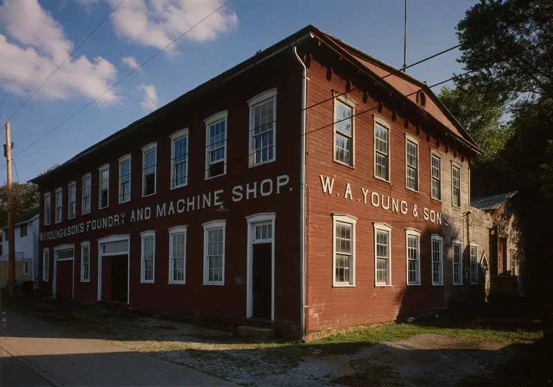
Rice's Landing occupies a narrow river terrace, steep hillslope and upland ridgetop beside the Monongahela River in northeastern Greene County. Its vernacular buildings, mostly one and two stories, date from the Mid-Victorian to Craftsman periods. The town was founded in 1780 by John Rice, and after canalization brought Lock #6 in 1856, it served as a shipping point for goods bound for much of northeastern Greene County. Industrial sites include the W. A. Young Machine Shop, a preserved river-side plant whose foundry was added during the coal boom, and the Excelsior Pottery, where Isaac Hewitt, Jr. produced salt-glazed stoneware in the early 1870s. The Dilworth deep shaft mine, opened by the 1900s, shipped coal directly into barges, and its fan house survives. The district was listed for its well-preserved river port and coal-era character and for its cohesive architecture, which the nomination compares favorably with other Upper Monongahela towns that lost integrity to floods and later development.
Significance in brief: The nomination argues the district is significant in the areas of transportation, industry and architecture as a preserved mid-19th to early-20th century Upper Monongahela River port and early industrial town. It cites the Young Machine Shop, the Excelsior Pottery, the Dilworth Mining Complex and Lock #6 as key resources, and states that the town integrated the river navigation system, rail transportation, bituminous coal mining and early industry in one location.
Machine-generated summary. This summary was generated by a language model from the official nomination document and has not been reviewed line by line by an editor. It may contain errors. Check the source document before relying on any detail. Source: nomination document (PDF) · National Archives catalog entry. NRHP reference 92001723, listed December 24, 1992. Summary generated October 2026 (model claude-haiku-5-5, prompt v1.1-2026-10-29, confidence medium).
Key facts
| Address | Roughly bounded by the Monongahela R., Water, Second, Bayard, Carmichael, High, Main and Ferry including Pumpkin Run Pk., Rice's Landing |
|---|---|
| County | Greene County |
| Listed | December 24, 1992 |
| Reference number | 92001723 |
| Resource type | District |
| Period of significance | 1854 - 1930 |
| Architectural style | Other/Victorian Vernacular; Bungalow; Colonial Revival |
| Criteria |
|
| Areas of significance | Industry, Historic - Non-Aboriginal, Transportation, Architecture |
| Level of significance | Local |
| Status (as stated in the nomination) | The now vacant garage is noted as vacant; the Rice's Landing bank now functions as a center for the town's historical society; the Dilworth fan house still operates for the new Dilworth Mine. |
| Acreage | 81 |
| Coordinates | 39.95168, -80.00339 (NPS GIS) |
What listing means for this property
This is a historic district. Buildings within its boundary are either contributing (they add to the district's significance) or non-contributing. Owners of contributing income-producing buildings can claim the 20% federal rehabilitation tax credit; homeowners should look at state credits. National Register districts impose no design review by themselves; a local historic district ordinance, if one exists, does (the difference explained).
General information, not legal or tax advice. Rules change; confirm with your State Historic Preservation Office or a qualified adviser.
Sources and further reading
- National Park Service, National Register of Historic Places database (snapshot May 2026), reference 92001723.
- Nomination form (PDF, National Archives) — catalog entry
- Wikipedia article (used for cross-checking only; text not reproduced here)
- Wikidata Q7322968
- This listing as JSON
Last updated October 2026. Found an error? See the editorial policy for how to report it.