Fort Roberdeau
Also known as: The Lead Mine Fort

Why it's listed
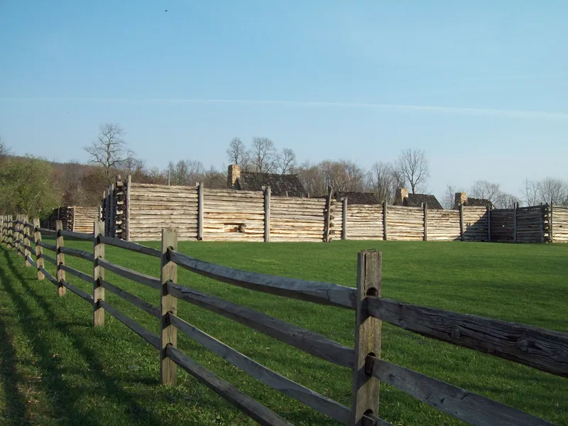
On the slope of Brush Mountain in Sinking Valley, Blair County, lie the remains of a frontier fort built in 1777-1778 under General Daniel Roberdeau, a Philadelphia merchant and member of the Committee of Safety. Lead deposits discovered in the valley were vital to the Continental Army, and Roberdeau was assigned to supervise the mines. The fort sheltered miners from attacks by Indians and Tories. Its stockade logs were laid horizontally because limestone made deep excavation difficult. Its lead mining effort was abandoned by 1779, yet the fort remained standing and was occupied at least through 1781, serving local settlers as a refuge. It is regarded as the only fort in the county built and manned by Continental soldiers, making it a rare surviving link to the region's wartime role. Archaeological work in the 1930s and 1940s uncovered the original foundations, which were then outlined in concrete by National Youth Administration workers before reconstruction stopped in 1941.
Significance in brief: The fort was erected in 1777-1778 by General Daniel Roberdeau to house miners working nearby lead deposits and protect them from Indians and Tories. It is described as the only fort in Blair County built and manned by soldiers of the Continental Army, and the form argues its significance rests on its military role and its connection to the lead supply for the Continental Army.
Machine-generated summary. This summary was generated by a language model from the official nomination document and has not been reviewed line by line by an editor. It may contain errors. Check the source document before relying on any detail. Source: nomination document (PDF) · National Archives catalog entry. NRHP reference 74001753, listed May 29, 1974. Summary generated October 2026 (model claude-haiku-5-5, prompt v1.1-2026-10-29, confidence medium).
Key facts
| Address | W of Culp off U.S. 220, Tyronne Township, Culp |
|---|---|
| County | Blair County |
| Listed | May 29, 1974 |
| Reference number | 74001753 |
| Resource type | Site |
| Period of significance | C. 1777-1781 |
| Areas of significance | Military |
| Level of significance | State |
| Status (as stated in the nomination) | Ruins; only the powder magazine walls and a masonry square remain above ground, with a concrete foundation outlining the fort poured 1939-1941 during a reconstruction that was discontinued in 1941. |
| Acreage | 2 |
| Coordinates | 40.58262, -78.27351 (NPS GIS) |
What listing means for this property
Sites (archaeological sites, battlefields, landscapes) are often listed with a restricted address to protect them from looting or disturbance. Listing is honorary for private owners; federal undertakings on or near the site go through Section 106 review, and state laws may protect burials and artefacts regardless of listing.
General information, not legal or tax advice. Rules change; confirm with your State Historic Preservation Office or a qualified adviser.
Sources and further reading
- National Park Service, National Register of Historic Places database (snapshot May 2026), reference 74001753.
- Nomination form (PDF, National Archives) — catalog entry
- Wikipedia article (used for cross-checking only; text not reproduced here)
- Wikidata Q5471933
- This listing as JSON
Last updated October 2026. Found an error? See the editorial policy for how to report it.