Lobb's Cemetery and Yohogania County Courthouse Site

Why it's listed
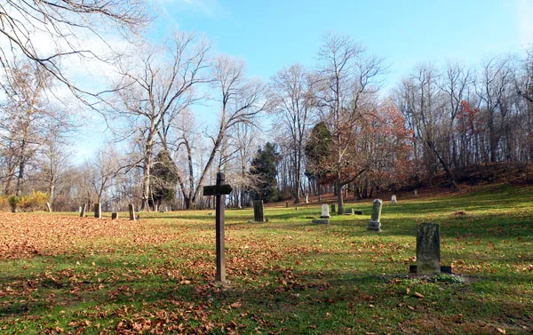
Lobb's Cemetery sits on a wooded bluff above the Monongahela River in West Elizabeth, Allegheny County, next to the reputed site of the Yohogania County Courthouse. The cemetery was used from the late 18th century into the late 20th, and its roughly 50 remaining stones range from early native stone markers to 19th- and 20th-century marble and granite. The site matters chiefly for its link to the Whiskey Rebellion. Federal troops wintered at the mouth of Lobb's Run during the unrest, and a smallpox outbreak killed several of them. Two officers, Lieutenant Alexander Beall and Captain Thomas Walker, both died in January 1795 aged 20 and have marked graves. Other graves belong to Andrew McFarlane, a Mingo Creek Society participant, and Gabriel Peterson, a Revolutionary War veteran who kept a tavern during the Rebellion. The courthouse, one of three courts Virginia set up on Pennsylvania soil, reflects the long rivalry over which state governed the region.
Significance in brief: The nomination argues the site is significant for its association with the late 18th-century governmental and judicial center at Yohogania County, a Virginia-established county court, and with the Whiskey Rebellion. Federal troops camped nearby and were buried here, and several men tied to the Rebellion are interred in the cemetery. It is described as the only known burial ground of federal troops who died during that campaign.
Machine-generated summary. This summary was generated by a language model from the official nomination document and has not been reviewed line by line by an editor. It may contain errors. Check the source document before relying on any detail. Source: nomination document (PDF) · National Archives catalog entry. NRHP reference 92001501, listed November 12, 1992. Summary generated October 2026 (model claude-haiku-5-5, prompt v1.1-2026-10-29, confidence high).
Key facts
| Address | Calamity Hollow Rd. at Lobb's Run, Jefferson Borough, West Elizabeth |
|---|---|
| County | Allegheny County |
| Listed | November 12, 1992 |
| Reference number | 92001501 |
| Resource type | Site |
| Period of significance | 1794-1832 |
| Criteria |
|
| Areas of significance | Politics/Government |
| Level of significance | Local |
| Acreage | 2.6 |
| Coordinates | 40.26306, -79.91609 (NPS GIS) |
What listing means for this property
Sites (archaeological sites, battlefields, landscapes) are often listed with a restricted address to protect them from looting or disturbance. Listing is honorary for private owners; federal undertakings on or near the site go through Section 106 review, and state laws may protect burials and artefacts regardless of listing.
General information, not legal or tax advice. Rules change; confirm with your State Historic Preservation Office or a qualified adviser.
Sources and further reading
- National Park Service, National Register of Historic Places database (snapshot May 2026), reference 92001501.
- Nomination form (PDF, National Archives) — catalog entry
- Wikipedia article (used for cross-checking only; text not reproduced here)
- Wikidata Q6663578
- This listing as JSON
Last updated October 2026. Found an error? See the editorial policy for how to report it.