Crawford, Col., Burn Site Monument

Why it's listed
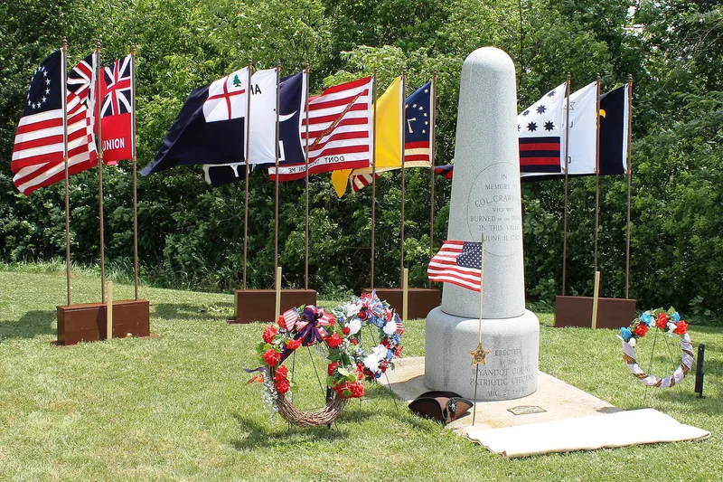
This sandstone monument, shaped like a cannon and standing about 8.5 feet tall on a round base, sits on a bluff above Tymochtee Creek east of Crawford, Ohio. Its inscription remembers Colonel Crawford, burned by Indians in the valley on June 11, 1782. John Gormley designed it, and B.L. Bauscher's marble works in Upper Sandusky made it in the summer of 1877 for the Pioneer Association of Wyandot County. The exact place of Crawford's death was never precisely documented, so the monument itself is the recognized resource. Its importance also comes from what happened around it. The dedication drew thousands of people to a picnic that formally organized the Wyandot Pioneer Association, and annual Pioneer Picnics with speakers, bands and choirs continued there until 1935. The monument has not been altered since it was erected and is seen as a link to the county's pioneer history. The form notes that the surrounding valley was threatened by a planned power line.
Significance in brief: The monument commemorates Colonel William Crawford's death by burning in 1782 during the campaign against Sandusky. The exact site of the burning is not documented, so the monument itself is nominated. From 1877 to 1935 it served as the focal point of the annual Wyandot Pioneer Association picnics, and it has become a pilgrimage site for county history.
Machine-generated summary. This summary was generated by a language model from the official nomination document and has not been reviewed line by line by an editor. It may contain errors. Check the source document before relying on any detail. Source: nomination document (PDF) · National Archives catalog entry. NRHP reference 82003667, listed April 15, 1982. Summary generated October 2026 (model claude-sonnet-5-5, prompt v1.0-2026-10-29, confidence medium).
Key facts
| Address | NE of Crawford, Crawford |
|---|---|
| County | Wyandot County |
| Listed | April 15, 1982 |
| Reference number | 82003667 |
| Resource type | Object |
| Period of significance | 1800-1899 |
| Architect / builder | Designed by John Gormley of Wyandot County; made by the marble works of B.L. Bauscher of Upper Sandusky |
| Areas of significance | Military |
| Level of significance | State |
| Status (as stated in the nomination) | Listed as unaltered and on its original site, in good condition; the form notes the setting is threatened by a planned high power line, and the picnic pavilion and grandstand are gone. |
| Acreage | 0.9 |
| Coordinates | 40.92304, -83.33435 (NPS GIS) |
What listing means for this property
For a publicly owned building or structure, listing mainly matters when federal funds, permits or licences are involved: projects then go through Section 106 review so effects on the property are considered. Listing also strengthens applications for preservation grants and, for leased income-producing uses, can enable the federal rehabilitation tax credit.
General information, not legal or tax advice. Rules change; confirm with your State Historic Preservation Office or a qualified adviser.
Sources and further reading
- National Park Service, National Register of Historic Places database (snapshot May 2026), reference 82003667.
- Nomination form (PDF, National Archives) — catalog entry
- Wikipedia article (used for cross-checking only; text not reproduced here)
- Wikidata Q5141759
- This listing as JSON
Last updated October 2026. Found an error? See the editorial policy for how to report it.