Mound Cemetery Mound
Also known as: Conus Mound; See Also:Mound Cemetery Mound (Boundary Increase

Why it's listed
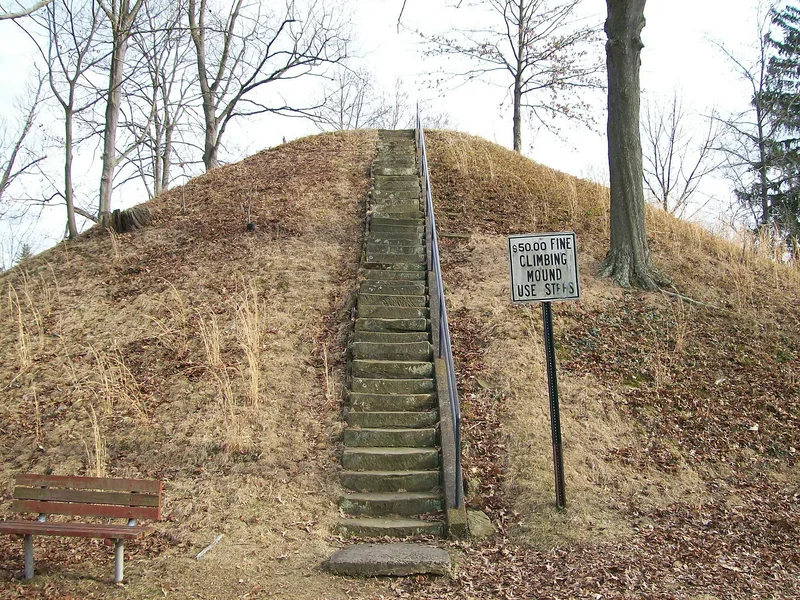
Conus Mound is a 30-foot-high earthen mound in Mound Cemetery, Marietta, Ohio. It measures about 112 feet north-south and 132 feet east-west, and an elliptical embankment with a five-foot-deep interior ditch surrounds it. The mound is probably Adena in origin, dating between 500 B.C. and A.D. 300. It is the surviving part of the Marietta Works, a ceremonial complex of mounds and earthen enclosures built by Adena, Hopewell and Mississippian peoples, most of which was destroyed as the city grew. Because a historic graveyard surrounds it, with burials dating to the Revolutionary War, the mound has never been excavated or potted. Stone steps, slabs and benches were added so that it could serve as a lookout, but it is otherwise unaltered. Caleb Atwater and Charles Whittlesey surveyed the site, and Squier and Davis published it in 1848. The listing recognizes it as a classic Late Adena monument with research potential. A later boundary revision expanded the nominated area to the fenced six-acre cemetery.
Significance in brief: The mound and its enclosure are all that remain of the Marietta Works, a large ceremonial complex built by Adena, Hopewell and Mississippian peoples. The form calls it a classic example of Late Adena culture in the Ohio Valley. It has never been excavated, so scientific study could yield information on the prehistory of the Muskingum Valley.
Machine-generated summary. This summary was generated by a language model from the official nomination document and has not been reviewed line by line by an editor. It may contain errors. Check the source document before relying on any detail. Source: nomination document (PDF) · National Archives catalog entry. NRHP reference 73001549, listed February 23, 1973. Summary generated October 2026 (model claude-sonnet-5-5, prompt v1.0-2026-10-29, confidence medium).
Key facts
| Address | 5th and Scammel Sts., Marietta |
|---|---|
| County | Washington County |
| Listed | February 23, 1973 |
| Reference number | 73001549 |
| Resource type | Site |
| Period of significance | 500 B.C. - A.D. 300 |
| Areas of significance | Prehistoric |
| Level of significance | State |
| Status (as stated in the nomination) | Described as in excellent, unaltered condition on its original site, publicly accessible and kept in perfect condition by the city. It is used as a lookout and rest area within the cemetery. |
| Acreage | 1 |
| Coordinates | 39.42034, -81.44246 (NPS GIS) |
What listing means for this property
Sites (archaeological sites, battlefields, landscapes) are often listed with a restricted address to protect them from looting or disturbance. Listing is honorary for private owners; federal undertakings on or near the site go through Section 106 review, and state laws may protect burials and artefacts regardless of listing.
General information, not legal or tax advice. Rules change; confirm with your State Historic Preservation Office or a qualified adviser.
Sources and further reading
- National Park Service, National Register of Historic Places database (snapshot May 2026), reference 73001549.
- Nomination form (PDF, National Archives) — catalog entry
- Wikidata Q34821111
- This listing as JSON
Last updated October 2026. Found an error? See the editorial policy for how to report it.