West Sister Island Light

Why it's listed
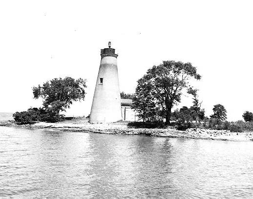
West Sister Island Light is a white-stuccoed lighthouse tower on the southwest end of West Sister Island, at the western end of Lake Erie near Toledo, Ohio. The site was reserved from public lands in 1838, and the light was built ten years later. In 1868 the conical stone tower was renovated with an interior brick cylinder, a cast-iron stairway, stone caps and sills, and a new lantern, and a keeper's dwelling was added. The tower is built of limestone rubble and brick and stands about 56 feet high. It was automated in 1937 when the last keeper left. The Army used the island for target practice during World War II, the keeper's dwelling was demolished around 1945, and the lantern was later removed and replaced by a battery-operated light. The island is now a national wildlife refuge. The lighthouse is considered one of the oldest surviving on Lake Erie and important to Great Lakes shipping growth.
Significance in brief: The inventory describes the light as among the oldest surviving lighthouses on Lake Erie. It played an important role in the growth of shipping on the Great Lakes. It remains an active coast light.
Machine-generated summary. This summary was generated by a language model from the official nomination document and has not been reviewed line by line by an editor. It may contain errors. Check the source document before relying on any detail. Source: nomination document (PDF) · National Archives catalog entry. NRHP reference 83002006, listed August 4, 1983. Summary generated October 2026 (model claude-sonnet-5-5, prompt v1.0-2026-10-29, confidence medium).
Key facts
| Address | West Sister Island, Toledo |
|---|---|
| County | Lucas County |
| Listed | August 4, 1983 |
| Reference number | 83002006 |
| Resource type | Structure |
| Areas of significance | Commerce, Engineering, Transportation |
| Level of significance | State |
| Status (as stated in the nomination) | Still in use as a coast light, automated in 1937; the lantern has been removed and the keeper's dwelling was torn down around 1945. Condition boxes are unreadable. |
| Acreage | 2 |
| Coordinates | 41.73708, -83.11050 (NPS GIS) |
What listing means for this property
National Register listing is honorary: it recognises significance and does not restrict what a private owner may do without federal money or permits. It unlocks the 20% federal rehabilitation tax credit for income-producing buildings, state credits in many states, and Section 106 review when federal agencies are involved. See what listing means in practice.
General information, not legal or tax advice. Rules change; confirm with your State Historic Preservation Office or a qualified adviser.
Sources and further reading
- National Park Service, National Register of Historic Places database (snapshot May 2026), reference 83002006.
- Nomination form (PDF, National Archives) — catalog entry
- Wikipedia article (used for cross-checking only; text not reproduced here)
- Wikidata Q80772845
- This listing as JSON
Last updated October 2026. Found an error? See the editorial policy for how to report it.