Old Enon Road Stone Arch Culvert
Also known as: Rocky Point Stone Arch Culvert; Odot Sfn 1253670; Stone Arch Culvert over Muddy Run on Enron Rd.

Why it's listed
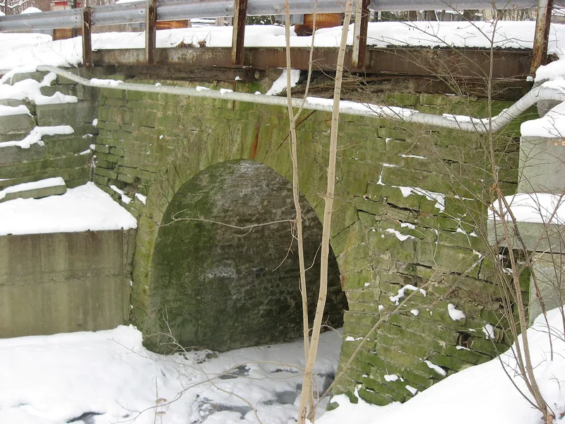
Spanning the rocky gorge of Mud Run at Rocky Point, this stone arch culvert carries Rocky Point Road, part of the old Enon Road, in Mad River Township, Clark County. Samuel S. Taylor built it in 1871 under a county contract of $450 plus the old wooden bridge it replaced. The structure is about 20 feet wide, 24 feet long and 16 feet high, with a barrel vault 12 feet wide. It is made of locally quarried dolomitic limestone, laid in mortar in well-formed courses, and rests directly on bedrock. Later changes include steel deck sections and guardrails added by 1972, concrete patching, and fill of reused architectural stone at the approaches. A 2006 engineering inspection found the masonry arch generally in good condition. The culvert is considered important as a rare surviving example of a once-common Ohio road structure. It is the oldest structure in the county's bridge inventory and its only remaining stone culvert.
Significance in brief: The nomination argues the culvert is a fine and rare example of a mid-sized single-span barrel-vaulted stone arch culvert, a type once common on Ohio roads. It is the oldest structure in the county's inventory of 241 active bridges and culverts and the only remaining stone culvert there. It also retains sound original stonework and good historical integrity despite later alterations.
Machine-generated summary. This summary was generated by a language model from the official nomination document and has not been reviewed line by line by an editor. It may contain errors. Check the source document before relying on any detail. Source: nomination document (PDF) · National Archives catalog entry. NRHP reference 09000209, listed April 16, 2009. Summary generated October 2026 (model claude-sonnet-5-5, prompt v1.0-2026-10-29, confidence medium).
Key facts
| Address | Rocky Pt. Rd. approx. 185 ft. W. of Old Mill Rd., Enon |
|---|---|
| County | Clark County |
| Listed | April 16, 2009 |
| Reference number | 09000209 |
| Resource type | Structure |
| Period of significance | 1871 |
| Architect / builder | Taylor, Samuel S. (1837-1930) |
| Architectural style | No style |
| Criteria |
|
| Areas of significance | Engineering |
| Level of significance | Local |
| Status (as stated in the nomination) | Original stonework is in good condition. The 1972-era steel deck and guardrails are heavily corroded, and the roadway is limited to one lane and 70% load capacity. The structure still carries a road. |
| Acreage | 0.9 |
| Coordinates | 39.86963, -83.87934 (NPS GIS) |
What listing means for this property
National Register listing is honorary: it recognises significance and does not restrict what a private owner may do without federal money or permits. It unlocks the 20% federal rehabilitation tax credit for income-producing buildings, state credits in many states, and Section 106 review when federal agencies are involved. See what listing means in practice.
General information, not legal or tax advice. Rules change; confirm with your State Historic Preservation Office or a qualified adviser.
Sources and further reading
- National Park Service, National Register of Historic Places database (snapshot May 2026), reference 09000209.
- Nomination form (PDF, National Archives) — catalog entry
- Wikipedia article (used for cross-checking only; text not reproduced here)
- Wikidata Q7083932
- This listing as JSON
Last updated October 2026. Found an error? See the editorial policy for how to report it.