Wiswell Road Covered Bridge
Also known as: Warner Hollow Bridge; Windsor Mills Bridge

Why it's listed
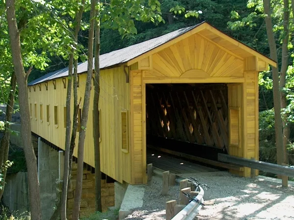
Spanning Phelps Creek Gorge southwest of Windsor Mills in Ashtabula County, Ohio, this covered bridge carries Wiswell Road more than 30 feet above the water. Built around 1867, it uses a Town Lattice truss of white pine fastened with hand-made iron pins. Three spans of 33, 42.3 and 40.3 feet give an overall length of 120.5 feet, resting on two piers and two abutments of stone blocks quarried from the gorge wall nearby. Later repairs added cut stone and concrete to the original fieldstone masonry. The crossing mattered because most buildings in Windsor Mills lay north of the gorge, and the only other route south ran miles out of the way. The bridge connected the southern area with Stoneville, a quarrying center, and with the Millbank Inn, which served as hotel, post office, store, skating rink and dance hall. Still in use and little altered, it was recognized for its engineering and its wooded setting.
Significance in brief: The bridge is a Town Lattice truss structure of white pine with hand-made iron pins, largely unaltered and still in use. It linked the area south of the gorge to Stoneville, a quarrying center, and to the buildings north of the creek, including the Millbank Inn, helping make Windsor Mills a vital village center. It is noted for engineering and for its scenic setting.
Machine-generated summary. This summary was generated by a language model from the official nomination document and has not been reviewed line by line by an editor. It may contain errors. Check the source document before relying on any detail. Source: nomination document (PDF) · National Archives catalog entry. NRHP reference 73001386, listed April 11, 1973. Summary generated October 2026 (model claude-sonnet-5-5, prompt v1.0-2026-10-29, confidence medium).
Key facts
| Address | Wiswell Rd. over Phelps Creek, Windsor Mills |
|---|---|
| County | Ashtabula County |
| Listed | April 11, 1973 |
| Reference number | 73001386 |
| Resource type | Structure |
| Period of significance | 19th Century; specific date 1867 or 1868 |
| Architectural style | Town Lattice truss |
| Areas of significance | Engineering |
| Level of significance | Local |
| Status (as stated in the nomination) | Condition listed as fair; bridge still in use, with only minor repair work and largely unaltered. Owned by Ashtabula County. |
| Acreage | 0.9 |
| Coordinates | 41.53318, -80.96379 (NPS GIS) |
What listing means for this property
For a publicly owned building or structure, listing mainly matters when federal funds, permits or licences are involved: projects then go through Section 106 review so effects on the property are considered. Listing also strengthens applications for preservation grants and, for leased income-producing uses, can enable the federal rehabilitation tax credit.
General information, not legal or tax advice. Rules change; confirm with your State Historic Preservation Office or a qualified adviser.
Sources and further reading
- National Park Service, National Register of Historic Places database (snapshot May 2026), reference 73001386.
- Nomination form (PDF, National Archives) — catalog entry
- Wikipedia article (used for cross-checking only; text not reproduced here)
- Wikidata Q8024660
- This listing as JSON
Last updated October 2026. Found an error? See the editorial policy for how to report it.