Harshaville Covered Bridge

Why it's listed
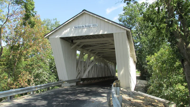
Spanning Cherry Fork at Harshaville in Oliver Township, this single-span wooden covered bridge carries county road #1 in Adams County, Ohio. It uses the Burr truss plan, patented by Theodore Burr, with ten-ply laminated arches set on both sides of double multiple kingpost trusses. The floor is 88 feet long, the overall length is 116 feet, and the roadway is 17 feet wide. Sheet metal siding and roof cover the frame, and the stone abutments have been reinforced with concrete. Two sets of concrete piers were added after a 1933 photograph showed none. The bridge is thought to predate the Civil War and reportedly served General John Morgan's Raiders in 1863, though no record names the builder or the exact date. It takes its name from the Harsha family, who ran the local mills from 1846 and gave their name to the community. It is valued as an outstanding example of Burr truss construction.
Significance in brief: The nomination calls it an outstanding example of the Burr truss plan patented by Theodore Burr. It was reportedly built before the Civil War and used by General John Morgan's Raiders in 1863. It also carries the name of the Harsha family, prominent local mill owners.
Machine-generated summary. This summary was generated by a language model from the official nomination document and has not been reviewed line by line by an editor. It may contain errors. Check the source document before relying on any detail. Source: nomination document (PDF) · National Archives catalog entry. NRHP reference 76001357, listed March 16, 1976. Summary generated October 2026 (model claude-sonnet-5-5, prompt v1.0-2026-10-29, confidence medium).
Key facts
| Address | SR 1, Harshaville |
|---|---|
| County | Adams County |
| Listed | March 16, 1976 |
| Reference number | 76001357 |
| Resource type | Structure |
| Period of significance | 1804-60 (pre-Civil War) |
| Architectural style | Burr truss covered bridge |
| Areas of significance | Engineering, Transportation |
| Level of significance | State |
| Status (as stated in the nomination) | Overall condition is described as good; owned by Adams County. The sheet metal siding and roof are in place, and concrete piers and abutment reinforcement were added later. |
| Acreage | 0.9 |
| Coordinates | 38.90791, -83.54442 (NPS GIS) |
What listing means for this property
For a publicly owned building or structure, listing mainly matters when federal funds, permits or licences are involved: projects then go through Section 106 review so effects on the property are considered. Listing also strengthens applications for preservation grants and, for leased income-producing uses, can enable the federal rehabilitation tax credit.
General information, not legal or tax advice. Rules change; confirm with your State Historic Preservation Office or a qualified adviser.
Sources and further reading
- National Park Service, National Register of Historic Places database (snapshot May 2026), reference 76001357.
- Nomination form (PDF, National Archives) — catalog entry
- Wikipedia article (used for cross-checking only; text not reproduced here)
- Wikidata Q5673866
- This listing as JSON
Last updated October 2026. Found an error? See the editorial policy for how to report it.