Mooresville Historic District (Boundary Increase)
Mooresville Historic District (Boundary Increase) is a historic district in Mooresville, Iredell County, North Carolina, listed on the National Register of Historic Places on April 23, 2020 (reference number 100005197). The National Park Service records its significance in Architecture and Community Planning and Development at the local level.
Facts from the NPS National Register database (); nomination summary October 2026. Last updated . Sources for each fact.

Coordinates come from Wikidata, not the National Park Service; treat the pin as approximate.
Why it's listed
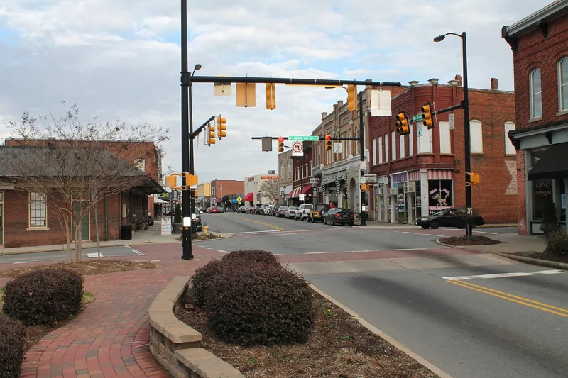
Mooresville's historic core is a district of more than eighty buildings spread over fifteen flat blocks, split by the railroad tracks that gave the town its reason for being. About three-fourths of the buildings are commercial, mostly brick and one to three stories, lined up along Main and Broad streets. A residential area of mainly frame houses lies to the southwest, with the 1899 First Presbyterian Church as its one religious building, and the Lorene Cotton Seed Oil Mill stands at the northwest as the only fully industrial property. A ca. 1920 brick depot marks the center of town, facing a small park. Sanborn maps show that most of the buildings were in place by 1925. Styles range from Italianate commercial blocks and a Queen Anne cottage to a ca. 1930 Art Deco-influenced auto showroom. Several storefronts, interiors and rear facades survive largely intact, including the D. E. Turner Hardware store, whose interior has never been remodeled.
Significance in brief: The district is the most concentrated surviving area of Mooresville's earliest commercial, residential and industrial buildings, most of them built between about 1880 and 1925. Its buildings show a range of late nineteenth and early twentieth century styles and a high level of design quality and craftsmanship, and many commercial buildings and rear facades remain little altered.
Machine-generated summary. This summary was generated by a language model from the official nomination document and has not been reviewed line by line by an editor. It may contain errors. Check the source document before relying on any detail. Source: nomination document (PDF) · National Archives catalog entry. NRHP reference 100005197, listed April 23, 2020. Summary generated October 2026 (model claude-sonnet-5-5, prompt v1.0-2026-10-29, confidence medium).
Key facts
| Official database NPS National Register database, ref. 100005197 , checked | |
|---|---|
| Address | Roughly includes properties fronting West Center Ave. from North Academy St. to Sherrill St.; Charlotte St.; 300 blk. of West McLelland Ave.; and properties fronting South Academy St. from West McLelland Ave. to Wilson St., Mooresville |
| County | Iredell County |
| Listed | April 23, 2020 |
| Reference number | 100005197 |
| Resource type | District |
| Areas of significance | Architecture, Community Planning and Development |
| Level of significance | Local |
| National Historic Landmark | No |
| Acreage | 55.5 |
| Official document, machine-extracted Nomination form (National Archives) , checked | |
| Architectural style | Late Victorian/Italianate, Italianate/Romanesque Revival/Renaissance Revival, Colonial Revival, Art Deco/Modernistic, late Greek Revival, Gothic Revival and Queen Anne in the residential and religious buildings |
| Status (as stated in the nomination) | Most buildings are in excellent or good condition; the former depot is being adapted for new use by a local artists' guild. Some storefronts were modernized in the 1950s and 1960s. |
| Secondary Wikidata Q6908351 | |
| Coordinates | 35.58306, -80.81250 |
| Computed Computed from NPS GIS district boundaries | |
| Within district | Mooresville Historic District |
What listing means for this property
This is a historic district. Buildings within its boundary are either contributing (they add to the district's significance) or non-contributing. Owners of contributing income-producing buildings can claim the 20% federal rehabilitation tax credit; homeowners should look at state credits. National Register districts impose no design review by themselves; a local historic district ordinance, if one exists, does (the difference explained).
General information, not legal or tax advice. Rules change; confirm with your State Historic Preservation Office or a qualified adviser.
Questions about Mooresville Historic District (Boundary Increase)
When was Mooresville Historic District (Boundary Increase) added to the National Register of Historic Places?
Mooresville Historic District (Boundary Increase) was listed on April 23, 2020. Its National Register reference number is 100005197.
Is Mooresville Historic District (Boundary Increase) a National Historic Landmark?
No. The National Park Service database (snapshot of May 2026) lists Mooresville Historic District (Boundary Increase) on the National Register but does not record it as a National Historic Landmark.
Where is Mooresville Historic District (Boundary Increase)?
Roughly includes properties fronting West Center Ave. from North Academy St. to Sherrill St.; Charlotte St.; 300 blk. of West McLelland Ave.; and properties fronting South Academy St. from West McLelland Ave. to Wilson St., Mooresville, Iredell County, North Carolina; coordinates 35.58306, -80.81250.
Why is Mooresville Historic District (Boundary Increase) historically significant?
According to a machine-generated summary of its nomination form: The district is the most concentrated surviving area of Mooresville's earliest commercial, residential and industrial buildings, most of them built between about 1880 and 1925. Its buildings show a range of late nineteenth and early twentieth century styles and a high level of design quality and craftsmanship, and many commercial buildings and rear facades remain little altered. Check the nomination document before relying on any detail.
Is Mooresville Historic District (Boundary Increase) in a historic district?
Yes. Its location falls within the Mooresville Historic District, itself listed on the National Register. (Computed from National Park Service boundary data; the district nomination's own list of contributing resources may differ.)
Where can I read the original nomination for Mooresville Historic District (Boundary Increase)?
The nomination form is a public record held by the National Archives: nomination document (PDF).
Sources and further reading
- National Park Service, National Register of Historic Places database (snapshot May 2026), reference 100005197.
- Nomination form (PDF, National Archives) — catalog entry
- Wikipedia article (used for cross-checking only; text not reproduced here)
- Wikidata Q6908351
- This listing as JSON
Last updated November 2026. Found an error? See the editorial policy for how to report it.