Roanoke Canal

Why it's listed
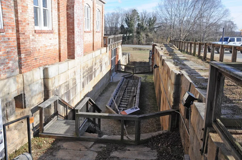
Running seven miles from Roanoke Rapids Lake to the Roanoke River at Weldon, this canal was built between about 1819 and 1823 to carry boats around the Great Falls of the Roanoke. English engineer Hamilton Fulton supervised much of the work, which included deep rock cuts, long embankments, four stone culverts, two sets of double stone locks and a single-arch stone aqueduct over Chockoyotte Creek. The canal was the most demanding part of the Roanoke Navigation System, which was meant to link the Blue Ridge Mountains with the Atlantic. Railroads reaching Weldon from 1833 onward drew away its trade, and navigation was discontinued after 1859. In the 1890s a new company reused the canal for water power and built a corn mill at Weldon in 1892, followed by a powerhouse around 1904. The first double lock and the aqueduct survive in good condition, while the mill buildings stand abandoned.
Significance in brief: The nomination argues the canal holds some of the most impressive and best-preserved early nineteenth-century canal construction in the nation. It was the most demanding engineering work of the Roanoke Navigation System and produced that system's most significant structures. Its later reuse for water power and milling, including an 1892 mill, adds to its story.
Machine-generated summary. This summary was generated by a language model from the official nomination document and has not been reviewed line by line by an editor. It may contain errors. Check the source document before relying on any detail. Source: nomination document (PDF) · National Archives catalog entry. NRHP reference 76001328, listed October 8, 1976. Summary generated October 2026 (model claude-sonnet-5-5, prompt v1.0-2026-10-29, confidence medium).
Key facts
| Address | Roanoke Rapids Lake SE to Weldon, Roanoke Rapids and |
|---|---|
| County | Halifax County |
| Listed | October 8, 1976 |
| Reference number | 76001328 |
| Resource type | Structure |
| Period of significance | 1819-1823, with 1892 and 1904 also listed as specific dates |
| Architect / builder | Hamilton Fulton |
| Areas of significance | Commerce, Engineering, Transportation |
| Level of significance | National |
| Status (as stated in the nomination) | Listed as unoccupied and not in use. The canal remains are visible in places, cut by roads or hidden by vegetation. The aqueduct is in good condition, and the mill and powerhouse at Weldon are abandoned. |
| Acreage | 140 |
| Coordinates | 36.45763, -77.63506 (NPS GIS) |
What listing means for this property
National Register listing is honorary: it recognises significance and does not restrict what a private owner may do without federal money or permits. It unlocks the 20% federal rehabilitation tax credit for income-producing buildings, state credits in many states, and Section 106 review when federal agencies are involved. See what listing means in practice.
Noted as vacant in the nomination. Nomination documents can be decades old; current status may differ. If you are considering buying an empty listed property, read the due-diligence checklist.
General information, not legal or tax advice. Rules change; confirm with your State Historic Preservation Office or a qualified adviser.
Sources and further reading
- National Park Service, National Register of Historic Places database (snapshot May 2026), reference 76001328.
- Nomination form (PDF, National Archives) — catalog entry
- Wikipedia article (used for cross-checking only; text not reproduced here)
- Wikidata Q19987833
- This listing as JSON
Last updated October 2026. Found an error? See the editorial policy for how to report it.