Hatteras Weather Bureau Station

Why it's listed
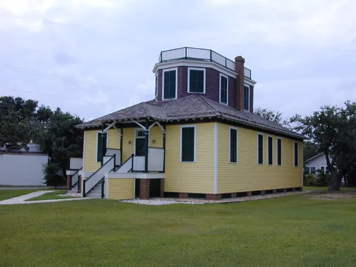
Built in 1901 on land bought from a local resident for $100, this 1½-story wood frame building in Hatteras village served as the office and living quarters for the U.S. Weather Bureau observer. It was the first building in the Outer Banks area built officially for the Bureau. Observers kept hourly surface readings and permanent records of wind, temperature, precipitation and pressure, and sent reports by telegraph to Washington. The station issued coastal forecasts and storm warnings for Dare and Hyde counties. The Weather Bureau moved its functions to Buxton in 1946. The property later passed through the General Services Administration and the Coast Guard before joining Cape Hatteras National Seashore in 1958. It then served as a university research residence and laboratory. The building lost its widow's walk and gained new windows and roofing, and its interior was repeatedly renovated. Today it is a duplex for park staff, while the original sheds and signal tower remain.
Significance in brief: It was the first building in the Outer Banks area built officially for the U.S. Weather Bureau. It housed the weather office and the observer's quarters, and handled observations, coastal forecasts and storm warnings for Dare and Hyde counties.
Machine-generated summary. This summary was generated by a language model from the official nomination document and has not been reviewed line by line by an editor. It may contain errors. Check the source document before relying on any detail. Source: nomination document (PDF) · National Archives catalog entry. NRHP reference 78000268, listed February 17, 1978. Summary generated October 2026 (model claude-sonnet-5-5, prompt v1.0-2026-10-29, confidence high).
Key facts
| Address | Off NC 12, Hatteras |
|---|---|
| County | Dare County |
| Listed | February 17, 1978 |
| Reference number | 78000268 |
| Resource type | Building |
| Period of significance | 1901 - 1952 |
| Architect / builder | Harding, architect |
| Areas of significance | Politics/Government, Communications |
| Level of significance | State |
| Status (as stated in the nomination) | Used as a duplex residence for National Park Service personnel; outbuildings still used for storage and the storm warning tower is maintained by the U.S. Coast Guard. Condition listed as fair and altered. |
| Acreage | 0.4 |
| Coordinates | 35.22030, -75.69025 (NPS GIS) |
What listing means for this property
For an income-producing building, listing (individually or as a contributing building in a district) is the gateway to the 20% federal rehabilitation tax credit on qualified rehabilitation costs, often stackable with state credits. Work claiming the credit must follow the Secretary of the Interior's Standards and be approved in advance.
Listing does not restrict a private owner acting without federal money or permits; where federal funding or licensing is involved, Section 106 review applies.
General information, not legal or tax advice. Rules change; confirm with your State Historic Preservation Office or a qualified adviser.
Sources and further reading
- National Park Service, National Register of Historic Places database (snapshot May 2026), reference 78000268.
- Nomination form (PDF, National Archives) — catalog entry
- Wikipedia article (used for cross-checking only; text not reproduced here)
- Wikidata Q3497450
- This listing as JSON
Last updated October 2026. Found an error? See the editorial policy for how to report it.