Caffeys Inlet Lifesaving Station

Why it's listed
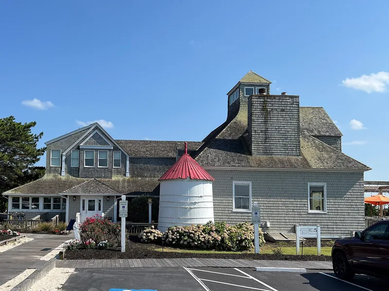
Caffey's Inlet Lifesaving Station is a shingle-style frame building on a narrow strip of land between the Atlantic Ocean and Currituck Sound, north of Duck. Its hipped-roof lookout tower, broad ramped boat-room openings and low profile suit the dune landscape and reflect its working purpose. Nearby are cylindrical wooden water tanks and a smaller support building. The station was one of the lifesaving stations set up on the Outer Banks in 1874 to aid ships wrecked in the area's treacherous waters. The standing building appears to date from reconstruction reported in 1897-1898 and survives almost unaltered. Its crews kept tower and beach watches and used Lyle guns and surfboats; in 1883 they rescued the nine-man crew of the Italian ship Angela. The Coast Guard abandoned the station in the late 1950s, and it passed into private ownership. It was listed as a well-preserved example of its type.
Significance in brief: The station was one of the lifesaving stations established on the Outer Banks in 1874 to aid ships wrecked in the dangerous waters off North Carolina. The present building is a well-preserved, almost unaltered example of the functional, picturesque shingled stations typical of the early twentieth century. It recalls an often heroic era of Outer Banks history, including its 1883 rescue of the crew of the Italian ship Angela.
Machine-generated summary. This summary was generated by a language model from the official nomination document and has not been reviewed line by line by an editor. It may contain errors. Check the source document before relying on any detail. Source: nomination document (PDF) · National Archives catalog entry. NRHP reference 78001942, listed January 30, 1978. Summary generated October 2026 (model claude-sonnet-5-5, prompt v1.0-2026-10-29, confidence high).
Key facts
| Address | N of Duck on SR 1200, Duck |
|---|---|
| County | Dare County |
| Listed | January 30, 1978 |
| Reference number | 78001942 |
| Resource type | Building |
| Architectural style | Shingle style |
| Areas of significance | Commerce, Transportation, Architecture |
| Level of significance | State |
| Status (as stated in the nomination) | Abandoned by the Coast Guard in the late 1950s and sold into private hands; the form reports the 1977 owner planned to use it as a restaurant while preserving it. Condition is listed as good. |
| Acreage | 5 |
| Coordinates | 36.22599, -75.77048 (NPS GIS) |
What listing means for this property
For an income-producing building, listing (individually or as a contributing building in a district) is the gateway to the 20% federal rehabilitation tax credit on qualified rehabilitation costs, often stackable with state credits. Work claiming the credit must follow the Secretary of the Interior's Standards and be approved in advance.
Listing does not restrict a private owner acting without federal money or permits; where federal funding or licensing is involved, Section 106 review applies.
General information, not legal or tax advice. Rules change; confirm with your State Historic Preservation Office or a qualified adviser.
Sources and further reading
- National Park Service, National Register of Historic Places database (snapshot May 2026), reference 78001942.
- Nomination form (PDF, National Archives) — catalog entry
- Wikipedia article (used for cross-checking only; text not reproduced here)
- Wikidata Q18205749
- This listing as JSON
Last updated October 2026. Found an error? See the editorial policy for how to report it.