Trinity Cemetery

Why it's listed
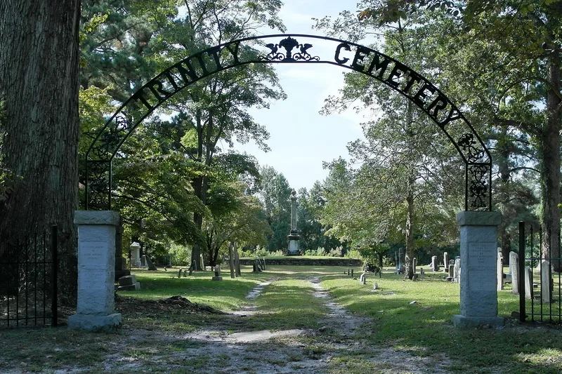
Trinity Cemetery is a small rural burial ground on a slight rise south of NC 33, near present-day Chocowinity in Beaufort County. The land was deeded to the Trinity Chapel congregation in 1860 by Penelope and Apsley Grist, and the cemetery was laid out in a grid of sixteen squares divided by walks, with 352 gravemarkers in the original section. Most markers are marble or granite, with segmental-arched and other tympanum shapes, and three bear signatures of their stonecarvers. The cemetery is the largest surviving trace of the community of Godley's Crossroads, whose church was moved to modern Chocowinity in 1938. Its stones record a high rate of infant and child deaths in the late nineteenth century. The cenotaph of Major General Bryan Grimes, who was killed in 1880, is its most elaborate monument. Its grave markers and family groupings are regarded as reflecting the community's faith, social life and funerary art.
Significance in brief: The nomination argues the cemetery is the most substantial physical remnant of the early community of Godley's Crossroads and early Chocowinity, and that its burials reflect the community's social history, including high infant and child mortality. It also argues the cemetery's grid plan and funerary art, including marble and granite markers with carved motifs and signed stonecutter work, are significant for their late nineteenth and early twentieth century design and craftsmanship.
Machine-generated summary. This summary was generated by a language model from the official nomination document and has not been reviewed line by line by an editor. It may contain errors. Check the source document before relying on any detail. Source: nomination document (PDF) · National Archives catalog entry. NRHP reference 11000545, listed August 19, 2011. Summary generated October 2026 (model claude-haiku-5-5, prompt v1.1-2026-10-29, confidence medium).
Key facts
| Address | NC 33, .07 mi. W. of jct. with NC 1157, Chocowinity |
|---|---|
| County | Beaufort County |
| Listed | August 19, 2011 |
| Reference number | 11000545 |
| Resource type | District |
| Period of significance | 1860-1938 |
| Architect / builder | Couper, J.D., stonecutter; Walsh, C. M., stonecutter |
| Criteria |
|
| Areas of significance | Social History, Art |
| Level of significance | Local |
| Status (as stated in the nomination) | The cemetery remains in use, with the original section maintained and extensions added in the twentieth century. |
| Acreage | 1 |
| Coordinates | 35.51583, -77.12044 (NPS GIS) |
What listing means for this property
This is a historic district. Buildings within its boundary are either contributing (they add to the district's significance) or non-contributing. Owners of contributing income-producing buildings can claim the 20% federal rehabilitation tax credit; homeowners should look at state credits. National Register districts impose no design review by themselves; a local historic district ordinance, if one exists, does (the difference explained).
General information, not legal or tax advice. Rules change; confirm with your State Historic Preservation Office or a qualified adviser.
Sources and further reading
- National Park Service, National Register of Historic Places database (snapshot May 2026), reference 11000545.
- Nomination form (PDF, National Archives) — catalog entry
- Wikipedia article (used for cross-checking only; text not reproduced here)
- Wikidata Q17053049
- This listing as JSON
Last updated October 2026. Found an error? See the editorial policy for how to report it.